NASA's TRMM Satellite Sees Hot Towers in Cyclone Koji
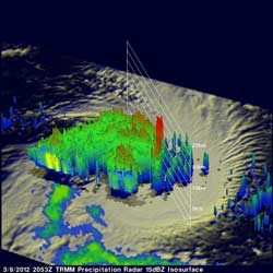
TRMM data from the flight over tropical storm Koji are shown in the 3-D image above. Those data reveal that an eye hadn't formed but powerful storm towers around KOJI's center were reaching heights of almost 15km (~9.3 miles).<br>Credit: NASA/SSAI, Hal Pierce <br>
The Tropical Rainfall Measuring Mission (TRMM) satellite passed directly above an intensifying tropical storm in the South Indian Ocean called Koji on March 8, 2012 at 2053 UTC (3:53 p.m. EST). A rainfall analysis was made from TRMM Microwave Imager (TMI) and Precipitation Radar (PR) data. Those TRMM data reveal that Koji was getting organized with bands of heavy rainfall spiraling into the storm's center.
One of its most important features of TRMM's Precipitation Radar (PR) instrument is its ability to provide three dimensional profiles of precipitation from the surface up to a height of about 20km (12 mile). PR data from the flight over tropical storm Koji are shown in the 3-D image above. Those data reveal that an eye hadn't formed but powerful storm towers around KOJI's center were reaching heights of almost 15 km (~9.3 miles).
On March 8, 2012 at 0900 UTC (4 a.m. EST), Tropical Storm Koji had maximum sustained winds near 55 knots (63.2 mph/102 kph). It was located near 17.1 South and 86.1 East, about 1000 miles southeast of Diego Garcia and moving to the west at 12 knots (13.8 mph/22.2 kph).
Koji has been predicted to increase in intensity and reach hurricane force with peak winds of 70kts (~80 mph) on March 8, 2012. Koji is predicted to remain at hurricane force for only one day and then weaken while traveling southwestward of the open waters of the South Indian Ocean.
Text Credit: Hal Pierce
SSAI/NASA's Goddard Space Flight Center, Greenbelt, Md.
Media Contact
All latest news from the category: Earth Sciences
Earth Sciences (also referred to as Geosciences), which deals with basic issues surrounding our planet, plays a vital role in the area of energy and raw materials supply.
Earth Sciences comprises subjects such as geology, geography, geological informatics, paleontology, mineralogy, petrography, crystallography, geophysics, geodesy, glaciology, cartography, photogrammetry, meteorology and seismology, early-warning systems, earthquake research and polar research.


Newest articles

Trotting robots reveal emergence of animal gait transitions
A four-legged robot trained with machine learning by EPFL researchers has learned to avoid falls by spontaneously switching between walking, trotting, and pronking – a milestone for roboticists as well…

Innovation promises to prevent power pole-top fires
Engineers in Australia have found a new way to make power-pole insulators resistant to fire and electrical sparking, promising to prevent dangerous pole-top fires and reduce blackouts. Pole-top fires pose…

Possible alternative to antibiotics produced by bacteria
Antibacterial substance from staphylococci discovered with new mechanism of action against natural competitors. Many bacteria produce substances to gain an advantage over competitors in their highly competitive natural environment. Researchers…

