NASA's Satellite Saw 'Power-Trigger' Around Hurricane Miriam's Center
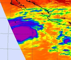
This infrared image of Tropical Storm Miriam was captured by the Atmospheric Infrared Sounder (AIRS) instrument aboard NASA's Aqua satellite. The image was taken on Sept. 23 at 2011 UTC and revealed that Miriam had a huge area (purple) of strong thunderstorms and heavy rainfall around the center of circulation. (Credit: NASA JPL, Ed Olsen)<br>
NASA's Aqua satellite passed over the eastern Pacific Ocean on Sept. 23 and the Atmospheric Infrared Sounder (AIRS) instrument captured an infrared image of Tropical Storm Miriam's cloud top temperatures. Tropical Storm Miriam is born that day, about 640 miles (1,025 km) south-southeast of the southern tip of Baja California. Cloud top temperatures are an indication of uplift in a storm.
Uplift is the push of air upward that allows formation of towering clouds and thunderstorms that make up a tropical cyclone. The infrared data indicated a large area of strongest thunderstorms and heaviest rainfall surrounding the center of circulation. Those cloud top temperatures exceeded -63 Fahrenheit (-52 Celsius).
On Friday, Sept. 24 at 11 a.m. EDT, Tropical Storm Miriam became an eastern Pacific hurricane with maximum sustained winds near 120 mph (195 kmh). Miriam was located about 410 miles (655 km) south-southwest of the southern tip of Baja California, Mexico, near latitude 17.7 North and longitude 112.9 West. Miriam is moving northwest near 12 mph (19 kmh) and a gradual turn to the west and southwest is expected later.
Visible imagery from NOAA's GOES-15 satellite suggests the formation of a small eye, while NASA's Tropical Rainfall Measuring Mission (TRMM) satellite data suggest that an outer eyewall is forming. The National Hurricane Center noted that barring an eyewall replacement, Miriam could strengthen even more in the next day.
Text credit: Rob Gutro
NASA's Goddard Space Flight Center, Greenbelt, Md.
Media Contact
All latest news from the category: Earth Sciences
Earth Sciences (also referred to as Geosciences), which deals with basic issues surrounding our planet, plays a vital role in the area of energy and raw materials supply.
Earth Sciences comprises subjects such as geology, geography, geological informatics, paleontology, mineralogy, petrography, crystallography, geophysics, geodesy, glaciology, cartography, photogrammetry, meteorology and seismology, early-warning systems, earthquake research and polar research.


Newest articles

Webb captures top of iconic horsehead nebula in unprecedented detail
NASA’s James Webb Space Telescope has captured the sharpest infrared images to date of a zoomed-in portion of one of the most distinctive objects in our skies, the Horsehead Nebula….

Cost-effective, high-capacity, and cyclable lithium-ion battery cathodes
Charge-recharge cycling of lithium-superrich iron oxide, a cost-effective and high-capacity cathode for new-generation lithium-ion batteries, can be greatly improved by doping with readily available mineral elements. The energy capacity and…

Novel genetic plant regeneration approach
…without the application of phytohormones. Researchers develop a novel plant regeneration approach by modulating the expression of genes that control plant cell differentiation. For ages now, plants have been the…

