Landsat 5 captures Missouri River flooding near Omaha
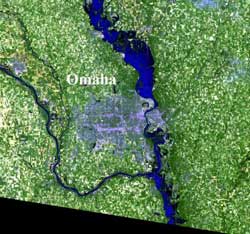
The Landsat 5 image is an enlargement of the area just north of Omaha. The flood waters show up as very dark blue and, where the water is shallow, medium blue. In the image, the Interstate is cut off by flood waters, just south of Missouri Valley, Iowa, and about 20 miles north of Omaha. Credit: USGS/NASA<br>
The Landsat 5 image captured was an enlargement of the area just north of Omaha. The flood waters show up as very dark blue and, where the water is shallow, medium blue. In the image, the Interstate is cut off by flood waters, just south of Missouri Valley, Iowa, and about 20 miles north of Omaha.
According to Omaha.com, officials from federal, state and local agencies will begin damage assessments from the flooding in the six Iowa counties that line the Missouri River. WOWT-TV reported on July 6 that part of U.S. Highway 30 from Blair to I-29 will be closed today, July 6, until the morning of July 8. The Iowa Department of Transportation closed the road to install a flood barrier.
On July 6, 2011 at 9:39 a.m. CDT, the National Weather Service posted several flood warnings. Flood warnings are in effect for: The Missouri River at Decatur affecting Monona, Burt and Thurston Counties; Missouri River near Blair affecting Harrison and Washington Counties; The Missouri River at Omaha affecting Pottawattamie, Douglas and Sarpy Counties; The Missouri River at Plattsmouth affecting Mills and Cass Counties; the Missouri River at Nebraska City affecting Fremont and Otoe Counties; the Missouri River at Brownville affecting Atchison and Nemaha Counties; and the Missouri River at Rulo affecting Holt and Richardson Counties.
The Landsat Program is a series of Earth-observing satellite missions jointly managed by NASA and the U.S. Geological Survey. Landsat satellites have been consistently gathering data about our planet since 1972. They continue to improve and expand this unparalleled record of Earth's changing landscapes, for the benefit of all. The next Landsat is scheduled to launch in December 2012.
For more information about the Landsat launching in 2012:
http://ldcm.gsfc.nasa.gov
For National Weather Service River flooding information, visit:
http://water.weather.gov/ahps2/index.php?wfo=oax
Media Contact
More Information:
http://www.nasa.govAll latest news from the category: Earth Sciences
Earth Sciences (also referred to as Geosciences), which deals with basic issues surrounding our planet, plays a vital role in the area of energy and raw materials supply.
Earth Sciences comprises subjects such as geology, geography, geological informatics, paleontology, mineralogy, petrography, crystallography, geophysics, geodesy, glaciology, cartography, photogrammetry, meteorology and seismology, early-warning systems, earthquake research and polar research.


Newest articles

Sea slugs inspire highly stretchable biomedical sensor
USC Viterbi School of Engineering researcher Hangbo Zhao presents findings on highly stretchable and customizable microneedles for application in fields including neuroscience, tissue engineering, and wearable bioelectronics. The revolution in…

Twisting and binding matter waves with photons in a cavity
Precisely measuring the energy states of individual atoms has been a historical challenge for physicists due to atomic recoil. When an atom interacts with a photon, the atom “recoils” in…

Nanotubes, nanoparticles, and antibodies detect tiny amounts of fentanyl
New sensor is six orders of magnitude more sensitive than the next best thing. A research team at Pitt led by Alexander Star, a chemistry professor in the Kenneth P. Dietrich…

