A NASA view of Tropical Cyclone Nanauk in the Arabian Sea
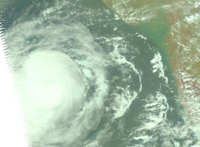
This near infrared image of Tropical Cyclone Nanauk was taken by the AIRS instrument aboard NASA's Aqua satellite on June 11 at 08:29 UTC (4:29 a.m. EDT). Credit: NASA JPL, Ed Olsen
As Tropical Cyclone 02A consolidated and strengthened into a tropical storm it was re-named Nanauk. NASA's Aqua satellite passed over Nanauk on June 11 at 08:29 UTC (4:29 a.m. EDT) and the Atmospheric Infrared Sounder (AIRS) captured an infrared and near-infrared image of the storm.
The near-infrared image provided an almost visible look at the clouds that revealed a well-rounded tropical cyclone with good circulation.
The infrared image showed that the storms that surrounded the center of circulation had very cold and high cloud tops. The AIRS images were created by NASA's Jet Propulsion Laboratory in Pasadena, California.
Animated enhanced infrared satellite imagery shows that a large area of strong convection and building thunderstorms has continued over the low-level circulation center.
Nanauk is still being buffeted by moderate to strong easterly vertical wind shear (20 to 30 knots). The wind shear has pushed the strongest thunderstorms into the western quadrant of the storm.
By 1500 UTC (11 a.m. EDT) Tropical cyclone Nanauk's maximum sustained winds were near 55 knots. It was centered near 17.5 north latitude and 65.8 east longitude, about 452 nautical miles east-southeast of Masirah Island. Nanauk was moving to the west-northwest at 6 knots.
Forecasters at the Joint Typhoon Warning Center expect Nanauk to continue strengthening for another day and a half before running into higher wind shear and dry air as it approaches the Arabian Peninsula.
Media Contact
More Information:
http://www.nasa.govAll latest news from the category: Earth Sciences
Earth Sciences (also referred to as Geosciences), which deals with basic issues surrounding our planet, plays a vital role in the area of energy and raw materials supply.
Earth Sciences comprises subjects such as geology, geography, geological informatics, paleontology, mineralogy, petrography, crystallography, geophysics, geodesy, glaciology, cartography, photogrammetry, meteorology and seismology, early-warning systems, earthquake research and polar research.


Newest articles

Webb captures top of iconic horsehead nebula in unprecedented detail
NASA’s James Webb Space Telescope has captured the sharpest infrared images to date of a zoomed-in portion of one of the most distinctive objects in our skies, the Horsehead Nebula….

Cost-effective, high-capacity, and cyclable lithium-ion battery cathodes
Charge-recharge cycling of lithium-superrich iron oxide, a cost-effective and high-capacity cathode for new-generation lithium-ion batteries, can be greatly improved by doping with readily available mineral elements. The energy capacity and…

Novel genetic plant regeneration approach
…without the application of phytohormones. Researchers develop a novel plant regeneration approach by modulating the expression of genes that control plant cell differentiation. For ages now, plants have been the…

