A 3-D Look at Philippe Provided Clues of Transition into a Hurricane
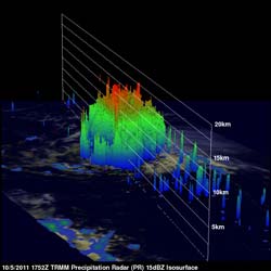
A 3-D rendering of TRMM precipitation radar data on October 5 at 1:52 p.m. EDT showed deep convective towers (towering thunderstorms) reached to heights of over 13km (~8 miles).<br>Credit: NASA/SSAI, Hal Pierce <br>
The wind shear lessened, and Philippe became a hurricane today, after 12 days of moving across the Atlantic Ocean. NASA's TRMM satellite saw towering thunderstorms and intense rainfall within Philippe yesterday, which provided forecasters with a clue that the storm was strengthening. Philippe reached hurricane status this morning, Oct. 6, 2011.
Over two days, the Tropical Rainfall Measuring Mission (TRMM) satellite provided forecasters with cloud heights and rainfall rates occurring within Tropical Storm Philippe. TRMM is managed by both NASA and the Japanese Space Agency, JAXA.
The National Hurricane Center (NHC) upgraded Philippe to a hurricane at 1500 UTC (11 a.m. EDT) on Thursday, October 6 2011. Earlier TRMM Microwave Imager (TMI) data from October 6, 2011 at 0024 UTC (Oct. 5 at 8:24 p.m. EDT) showed that tropical storm Philippe's center of circulation had become better defined and an eyewall was forming. Microwave satellite imagery also shows an eye-like feature, while the visible imagery from NOAA's GOES satellite hints at the indication of an eye, although mostly covered with clouds.
On Oct. 6, Philippe's maximum sustained winds were near 80 mph (130 kmh). Philippe is a Category One hurricane on the Saffir-Simpson scale, but some weakening is forecast in the next two days. Philippe is located about 425 miles (680 km) southeast of Bermuda, near 27.8 North and 60.0 West. The hurricane is moving to the north-northeast near 9 mph (15 kmh) and is expected to move toward the northeast and speed up.
The TRMM satellite also had an excellent look at Philippe earlier on Wednesday, October 5, 2011 at 1752 UTC (1:52 p.m. EDT). TRMM's Precipitation Radar (PR) scanned directly over Philippe and revealed that Philippe had bands of intense rainfall that around the southeast side of the center of circulation.
A 3-D rendering of that TRMM PR data showed deep convective towers reached to heights of over 13km (~8 miles). Previous research from NASA scientists show that whenever these “hot towers” are spotted within a tropical cyclone, the storm typically intensifies within six hours, and Philippe became a hurricane today.
Text credit: Hal Pierce/Rob Gutro
SSAI/NASA/Goddard Space Flight Center, Greenbelt, Md.
Media Contact
All latest news from the category: Earth Sciences
Earth Sciences (also referred to as Geosciences), which deals with basic issues surrounding our planet, plays a vital role in the area of energy and raw materials supply.
Earth Sciences comprises subjects such as geology, geography, geological informatics, paleontology, mineralogy, petrography, crystallography, geophysics, geodesy, glaciology, cartography, photogrammetry, meteorology and seismology, early-warning systems, earthquake research and polar research.


Newest articles

Sea slugs inspire highly stretchable biomedical sensor
USC Viterbi School of Engineering researcher Hangbo Zhao presents findings on highly stretchable and customizable microneedles for application in fields including neuroscience, tissue engineering, and wearable bioelectronics. The revolution in…

Twisting and binding matter waves with photons in a cavity
Precisely measuring the energy states of individual atoms has been a historical challenge for physicists due to atomic recoil. When an atom interacts with a photon, the atom “recoils” in…

Nanotubes, nanoparticles, and antibodies detect tiny amounts of fentanyl
New sensor is six orders of magnitude more sensitive than the next best thing. A research team at Pitt led by Alexander Star, a chemistry professor in the Kenneth P. Dietrich…

