NASA Sees Large Decrease in Cyclone Sandra's Rainfall Intensity
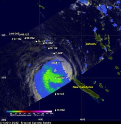
TRMM's Microwave Imager (TMI) data showed Sandra's rainfall on March 11, 2013 at 2124 UTC. Moderate rainfall appears in green. Sandra's previous and forecast locations are shown overlaid in white on this rainfall analysis. NASA/SSAI, Hal Pierce <br>
On March 11, 2013, NASA's TRMM satellite twice flew above weakening tropical cyclone Sandra as it was passing to the west of New Caledonia in the southern Pacific Ocean.
TRMM's Precipitation Radar (PR) had a very good view of Sandra as it passed directly above the tropical cyclone on March 11 at 1312 UTC (9:12 a.m. EST). TRMM PR measured rainfall at the extreme rate of over 206 mm (~8 inches) per hour in an area southwest of Sandra's eye. Those TRMM PR data also showed that very little rain was occurring north of the weakening tropical cyclone's eye.
New Caledonia escaped the heaviest precipitation as the center of Sandra remained off-shore.
Later on that day at 2124 UTC (4:24 p.m. EDT), TRMM's Microwave Imager (TMI) data identified diminished rainfall rates. The heaviest rains occurring south of Sandra's center at that time was falling at a rate of 30 mm (1.18 in) per hour. Wind shear continues to increase from the north and push the precipitation south of Sandra's center. Sandra's center has since become fully exposed to outside winds as the intensity of rainfall has diminished.
On Mar. 13 at 0300 UTC, Sandra's maximum sustained winds were near 55 knots (63.2 mph/101.9 kph). Sandra was located near 24.1 south and 161.5 east, about 270 nautical miles (310.7 miles/500 km ) west-southwest of Noumea, New Caledonia. Sandra was moving to the south-southwest at 8 knots (9.2 mph/14.8 kph).
Sandra is moving into an area of high vertical wind shear and colder sea surface temperatures that are expected to make the storm transform into a cold-core system before it dissipates over the next couple of days.
Text credit: Rob Gutro
NASA's Goddard Space Flight Center, Greenbelt, Md.
Media Contact
All latest news from the category: Earth Sciences
Earth Sciences (also referred to as Geosciences), which deals with basic issues surrounding our planet, plays a vital role in the area of energy and raw materials supply.
Earth Sciences comprises subjects such as geology, geography, geological informatics, paleontology, mineralogy, petrography, crystallography, geophysics, geodesy, glaciology, cartography, photogrammetry, meteorology and seismology, early-warning systems, earthquake research and polar research.


Newest articles

Sea slugs inspire highly stretchable biomedical sensor
USC Viterbi School of Engineering researcher Hangbo Zhao presents findings on highly stretchable and customizable microneedles for application in fields including neuroscience, tissue engineering, and wearable bioelectronics. The revolution in…

Twisting and binding matter waves with photons in a cavity
Precisely measuring the energy states of individual atoms has been a historical challenge for physicists due to atomic recoil. When an atom interacts with a photon, the atom “recoils” in…

Nanotubes, nanoparticles, and antibodies detect tiny amounts of fentanyl
New sensor is six orders of magnitude more sensitive than the next best thing. A research team at Pitt led by Alexander Star, a chemistry professor in the Kenneth P. Dietrich…

