New NASA Satellite Takes the Salton Sea's Temperature
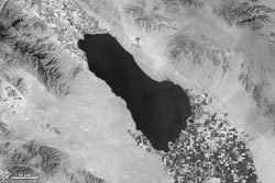
The Salton Sea in Southern California and nearby irrigated fields stand out in this image taken Mar. 24, 2013, by the Thermal Infrared Sensor (TIRS) instrument on the Landsat Data Continuity Mission (LDCM) satellite. Darker areas of the image are cooler, while lighter areas are warmer. <br>Credit: USGS/NASA's Earth Observatory<br>
If you looked at the Salton Sea in person, your eyes would not see anything presented in the LDCM image. Instead of showing visible light, the image shows the amount of heat — or thermal energy — radiating from the landscape and detected by the Thermal Infrared Sensor, or TIRS, instrument on LDCM. Cooler areas are dark, while warm areas are bright.
The dark squares in the LDCM's image of the Salton Sea are fields where plants can absorb irrigation water before sweating it off through a process called transpiration. Just like when people sweat, plants cool down when they transpire. The combination of transpiration and water evaporating from the ground itself — called evapotranspiration — drops the temperature of the irrigated land. Those cool temperatures, indicating healthy, well-watered plants, are picked up by TIRS.
“What you're looking at is infrared light that's generated by the Earth itself,” said Dennis Reuter, TIRS instrument scientist at NASA's Goddard Space Flight Center in Greenbelt, Md. TIRS is one of two instruments on the newest spacecraft in the Landsat family, launched Feb. 11 and currently in its on-orbit calibration and checkout phase.
While its partner instrument records reflected sunlight, TIRS complements that view with temperature readings across swaths of Earth's surface. The Goddard-designed detectors in the TIRS instruments can pick up two different bands of thermal infrared energy, which excite electrons and create an electrical signal. With TIRS measuring the strength of those signals, corresponding to temperatures on the ground, scientists can generate images like this one of the Salton Sea.
The view you get from TIRS is similar to what you've seen on television crime shows when cops use thermal imagers to track warm-bodied suspects moving around inside of a building. With Landsat, though, scientists use the thermal bands to track down water. Dark pixels representing cool spots and light pixels of hot spots are key to helping water managers determine where the valuable resource is being used for irrigation, especially in the arid western United States.
“You're using the temperature of a plant as a sort of surrogate measurement for the irrigation going on,” Reuter said.
The Landsat program is a joint mission of NASA and the U.S. Geological Survey. Once LDCM completes its on-board calibration and check-out phase in late May, the satellite will be handed over to the USGS and renamed Landsat 8. Data from TIRS and LDCM's second instrument, the Operational Land Imager, will be processed, archived and distributed from the Earth Resources and Observation Science Center in Sioux Falls, S.D., for free over the Internet.
Kate Ramsayer
NASA's Earth Science News Team
Media Contact
All latest news from the category: Earth Sciences
Earth Sciences (also referred to as Geosciences), which deals with basic issues surrounding our planet, plays a vital role in the area of energy and raw materials supply.
Earth Sciences comprises subjects such as geology, geography, geological informatics, paleontology, mineralogy, petrography, crystallography, geophysics, geodesy, glaciology, cartography, photogrammetry, meteorology and seismology, early-warning systems, earthquake research and polar research.


Newest articles

Why getting in touch with our ‘gerbil brain’ could help machines listen better
Macquarie University researchers have debunked a 75-year-old theory about how humans determine where sounds are coming from, and it could unlock the secret to creating a next generation of more…

Attosecond core-level spectroscopy reveals real-time molecular dynamics
Chemical reactions are complex mechanisms. Many different dynamical processes are involved, affecting both the electrons and the nucleus of the present atoms. Very often the strongly coupled electron and nuclear…

Free-forming organelles help plants adapt to climate change
Scientists uncover how plants “see” shades of light, temperature. Plants’ ability to sense light and temperature, and their ability to adapt to climate change, hinges on free-forming structures in their…

