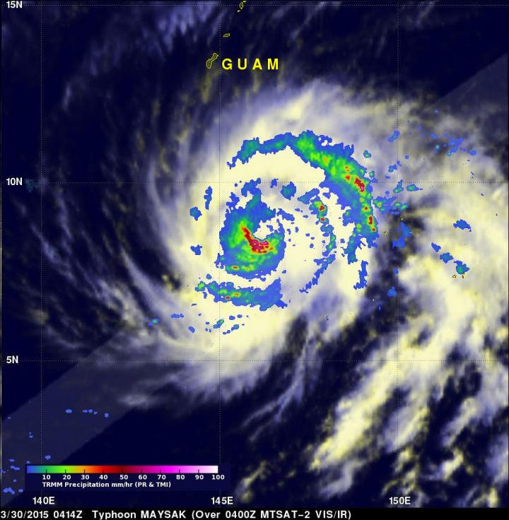
NASA sees Maysak become a super typhoon

On March 30, TRMM data showed heaviest rainfall (red) southwest of the center, and in fragmented bands of thunderstorms northeast of the center. In both of those places rainfall was in excess of 50 mm per hour. Image Credit: NASA/SSAI/JAXA, Hal Pierce
NASA's Aqua satellite captured an image of Typhoon Maysak as it strengthened into a super typhoon on March 31, reaching Category 5 hurricane status on the Saffir-Simpson Wind Scale. The TRMM and GPM satellites, both satellites are co-managed by NASA and the Japan Aerospace Exploration Agency captured rainfall and cloud data that revealed heavy rainfall and high thunderstorms in the strengthening storm.
On March 31, in Micronesia a typhoon warning is in effect for Yap, Fais and Ulithi in Yap State. For updated warnings visit: http://www.
The Tropical Rainfall Measuring Mission (TRMM) satellite has been collecting valuable scientific data since November 1997. Early on March 30, the satellite collected rainfall data as it flew directly above Maysak at 04:14 UTC (12:14 a.m. EDT) when maximum sustained winds were near 85 knots (98 mph). Rainfall data was collected by TRMM's Microwave Imager (TMI) and Precipitation Radar (PR) instruments and showed heaviest rainfall southwest of the center, and in fragmented bands of thunderstorms northeast of the center. In both of those places rainfall was in excess of 50 mm/2 inches per hour.
A little over eight hours later at 12:25 UTC (8:25 a.m. EDT) the Global Precipitation Measurement or GPM core observatory satellite captured rainfall data on Maysak. GPM rainfall data was combined with reflectivity data from GPM's Radar (Ku Band) to provide a 3-D image of Maysak's storm top heights. The Ku Band radar data sliced through the western side of the typhoon and showed that a few intense storms on this side of Maysak were reaching heights close to 16 km (9.9 miles)
The next day, March 31, the Moderate Resolution Imaging Spectroradiometer or MODIS instrument that flies aboard NASA's Aqua satellite captured this visible image of Super Typhoon Maysak at 3:55 UTC. The MODIS image showed the Maysak maintained its 15 nautical-mile (17.2 mile/27.7 km) wide eye.
On March 31 at 0900 UTC (5 a.m. EDT), Super typhoon Maysak's maximum sustained winds were near 140 knots (161.1 mph/ 259.3 kph). Hurricane-force winds extended 40 nautical miles (46 mile/74 km) from the center, and tropical storm-force winds extended 100 nautical miles (115 miles/185 km) from the center.
Maysak was centered near 10.0 north latitude and 141.3 east longitude, just 49 nautical miles (56.3 miles/90.7 km) east-northeast of Fais. Maysak was moving to the west-northwest at 12 knots. Maysak is generating 40-foot (12.9 meter) high seas.
Maysak is moving west-northwest through Yap State in Micronesia, and is continuing to strengthen. The JTWC forecast calls for Maysak to peak at 155 knots (178.4 mph/ 287.1 kph) in one or two days' time, before a weakening trend commences. Maysak is currently forecast to make landfall in Luzon sometime on April 5 as a typhoon.
Media Contact
All latest news from the category: Earth Sciences
Earth Sciences (also referred to as Geosciences), which deals with basic issues surrounding our planet, plays a vital role in the area of energy and raw materials supply.
Earth Sciences comprises subjects such as geology, geography, geological informatics, paleontology, mineralogy, petrography, crystallography, geophysics, geodesy, glaciology, cartography, photogrammetry, meteorology and seismology, early-warning systems, earthquake research and polar research.
Newest articles

Webb captures top of iconic horsehead nebula in unprecedented detail
NASA’s James Webb Space Telescope has captured the sharpest infrared images to date of a zoomed-in portion of one of the most distinctive objects in our skies, the Horsehead Nebula….

Cost-effective, high-capacity, and cyclable lithium-ion battery cathodes
Charge-recharge cycling of lithium-superrich iron oxide, a cost-effective and high-capacity cathode for new-generation lithium-ion batteries, can be greatly improved by doping with readily available mineral elements. The energy capacity and…

Novel genetic plant regeneration approach
…without the application of phytohormones. Researchers develop a novel plant regeneration approach by modulating the expression of genes that control plant cell differentiation. For ages now, plants have been the…


