NASA Sees Warming Cloud Tops Indicating Tropical Storm Tony Weakening
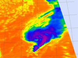
The AIRS instrument aboard NASA's Aqua satellite captured infrared imagery of Tropical Storm Tony on Oct. 24 at 12:17 p.m. EDT that showed the strongest thunderstorms (purple) east of the center of circulation but cloud top temperatures are warming. Those thunderstorms are reaching high into the troposphere where cloud top temperatures are as cold as -63 Fahrenheit (-52 Celsius).<br>Credit: NASA JPL, Ed Olsen <br>
When that strength wanes, the cloud tops drop and become less cold. That's because the higher you go in the troposphere, the colder it gets. NASA satellite infrared data has revealed that Tropical Storm Tony's cloud top temperatures are warming and the storm is weakening.
The Atmospheric Infrared Sounder (AIRS) instrument aboard NASA's Aqua satellite captured infrared imagery of Tropical Storm Tony on Oct. 24 at 12:17 p.m. EDT that showed the strongest thunderstorms east of the center of circulation, but cloud top temperatures are warming. Those thunderstorms are reaching high into the troposphere where cloud top temperatures are as cold as -63 Fahrenheit (-52 Celsius). The cloud pattern in Tony is also becoming less organized.
On Oct. 25, 2012 at 5 a.m. EDT Tropical Storm Tony had maximum sustained winds near 45 mph (75 kph). Tony was moving to the east-northeast near 23 mph (37 kph) and this general motion is expected to continue during the next couple of days. Tony's center is far from land, about 835 miles (1,345 km) southwest of the Azores Islands near 30.4 North latitude and 38.4 West longitude. Tropical storm force winds extend outward up to 105 miles (165 km) from the center.
According to the National Hurricane Center discussion of Tony, “the southwesterly winds have not substantially separated the surface circulation from the convective canopy, although a combination of the shear and cooler waters has weakened the deep convection.”
The National Hurricane Center expects Tony to start losing tropical characteristics today and dissipate over the weekend of Oct. 27 and 28.
Text credit: Rob Gutro
NASA's Goddard Space Flight Center, Greenbelt, Md.
Media Contact
All latest news from the category: Earth Sciences
Earth Sciences (also referred to as Geosciences), which deals with basic issues surrounding our planet, plays a vital role in the area of energy and raw materials supply.
Earth Sciences comprises subjects such as geology, geography, geological informatics, paleontology, mineralogy, petrography, crystallography, geophysics, geodesy, glaciology, cartography, photogrammetry, meteorology and seismology, early-warning systems, earthquake research and polar research.


Newest articles

Sea slugs inspire highly stretchable biomedical sensor
USC Viterbi School of Engineering researcher Hangbo Zhao presents findings on highly stretchable and customizable microneedles for application in fields including neuroscience, tissue engineering, and wearable bioelectronics. The revolution in…

Twisting and binding matter waves with photons in a cavity
Precisely measuring the energy states of individual atoms has been a historical challenge for physicists due to atomic recoil. When an atom interacts with a photon, the atom “recoils” in…

Nanotubes, nanoparticles, and antibodies detect tiny amounts of fentanyl
New sensor is six orders of magnitude more sensitive than the next best thing. A research team at Pitt led by Alexander Star, a chemistry professor in the Kenneth P. Dietrich…

