NASA sees Halloween Typhoon Krosa lashing Luzon, Philippines
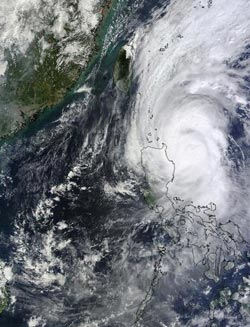
On Oct.31 at 0255 UTC, NASA's Terra satellite captured this picture of Tropical Storm Krosa's western edge over Luzon in the northern Philippines.<br><br>Credit: NASA Goddard MODIS Rapid Response Team<br>
On Oct. 30 at 0525 UTC/1:25 a.m. EDT NASA's Tropical Rainfall Measuring Mission or TRMM satellite captured a good daytime view of Typhoon Krosa. A rainfall analysis derived from TRMM's Microwave Imager (TMI) and Precipitation Radar (PR) data was combined into a visible and infrared image from TRMM's Visible and InfraRed Scanner (VIRS).
TRMM PR data found precipitation falling at a rate of about 81mm/~3.2 inches per hour in strong convective storms near Krosa's center.
On Oct.31 at 0255 UTC, the Moderate Resolution Imaging Spectroradiometer instrument known as MODIS that flies aboard NASA”s Terra satellite captured a picture of Tropical Storm Krosa. The MODIS image showed Krosa's western edge over Luzon in the northern Philippines
At 1500 UTC/11 a.m. EDT, Krosa's center was over land in extreme northern Luzon, and headed for the South China Sea. At that time, Krosa's maximum sustained winds were near 90 knots/103.6 mph/ 166.7 kph. The center of Krosa was located near 18.4 north and 121.2 east, about 227 nautical miles/261 miles/420 km north-northeast of Manila, Philippines. It was headed to the west-northwest at 12 knots/13.8 mph/22.22 kph.
Satellite imagery on Oct. 31 showed that Krosa had an eye 25 nautical miles/28.7 km/46.3 km in diameter at landfall in northern Luzon.
Krosa is expected to re-intensify in the South China Sea and affect Hainan Island, China before making a final landfall in northern Vietnam.
Media Contact
More Information:
http://www.nasa.govAll latest news from the category: Earth Sciences
Earth Sciences (also referred to as Geosciences), which deals with basic issues surrounding our planet, plays a vital role in the area of energy and raw materials supply.
Earth Sciences comprises subjects such as geology, geography, geological informatics, paleontology, mineralogy, petrography, crystallography, geophysics, geodesy, glaciology, cartography, photogrammetry, meteorology and seismology, early-warning systems, earthquake research and polar research.


Newest articles

Microscopic basis of a new form of quantum magnetism
Not all magnets are the same. When we think of magnetism, we often think of magnets that stick to a refrigerator’s door. For these types of magnets, the electronic interactions…

An epigenome editing toolkit to dissect the mechanisms of gene regulation
A study from the Hackett group at EMBL Rome led to the development of a powerful epigenetic editing technology, which unlocks the ability to precisely program chromatin modifications. Understanding how…

NASA selects UF mission to better track the Earth’s water and ice
NASA has selected a team of University of Florida aerospace engineers to pursue a groundbreaking $12 million mission aimed at improving the way we track changes in Earth’s structures, such…

