NASA sees Chris become first hurricane of Atlantic season
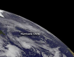
This visible image was captured by NOAA's GOES-13 satellite on June 21 at 1445 UTC (10:45 a.m. EDT) shows Hurricane Chris in the North Atlantic Ocean. Credit: NASA/NOAA GOES Project<br>
Infrared satellite imagery from NASA's Aqua satellite have revealed that the clouds around Hurricane Chris' eye have reached a cold peak early on June 21 when it was first designated a hurricane, and have since warmed.
The thunderstorms that surround Chris' eye are now between -60 and -70 Celsius. Cloud top temperatures that cold indicate strong, high, thunderstorms with the potential for heavy rainfall.
When thunderstorm cloud tops cool, it means there's more uplight in the atmosphere, which can push cloud tops higher and build stronger thunderstorms. When cloud top temperatures warm, it means the cloud tops are falling, and the push of the air upward is lesser than it was before, and the storm is weakening. As a result, forecasters at the National Hurricane Center expect Chris to become a post-tropical cyclone on Friday, June 22. That weakening is expected because Chris is moving into stable air and cooler waters.
NOAA's GOES-13 satellite captured a visible image of Chris on June 21 at 1445 UTC (10:45 a.m. EDT). The image was created by NASA's GOES Project at NASA's Goddard Space Flight Center in Greenbelt, Md. and it showed Hurricane Chris with a tight circulation center.
At 11 a.m. EDT, Chris had 75 mph (120 kph) winds. It was located about 625 miles (1005 km) southeast of Cape Race, Newfoundland, Canada, near 41.1 North and 43.2 West. It was moving to the northeast at 20 mph (32 kph) and had a minimum central pressure of 987 millibars.
Chris is expected to turn in the Altantic over the next couple of days. First a turn to the north and then northwest and finally south. Chris is moving around a large mid-to-upper level low pressure area and will eventually become absorbed within the upper level low in the next couple of days.
Media Contact
More Information:
http://www.nasa.govAll latest news from the category: Earth Sciences
Earth Sciences (also referred to as Geosciences), which deals with basic issues surrounding our planet, plays a vital role in the area of energy and raw materials supply.
Earth Sciences comprises subjects such as geology, geography, geological informatics, paleontology, mineralogy, petrography, crystallography, geophysics, geodesy, glaciology, cartography, photogrammetry, meteorology and seismology, early-warning systems, earthquake research and polar research.


Newest articles

Microscopic basis of a new form of quantum magnetism
Not all magnets are the same. When we think of magnetism, we often think of magnets that stick to a refrigerator’s door. For these types of magnets, the electronic interactions…

An epigenome editing toolkit to dissect the mechanisms of gene regulation
A study from the Hackett group at EMBL Rome led to the development of a powerful epigenetic editing technology, which unlocks the ability to precisely program chromatin modifications. Understanding how…

NASA selects UF mission to better track the Earth’s water and ice
NASA has selected a team of University of Florida aerospace engineers to pursue a groundbreaking $12 million mission aimed at improving the way we track changes in Earth’s structures, such…

