NASA infrared satellite imagery shows Cyclone Cherono dwindling
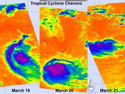
These three days of AIRS infrared imagery show how wind shear took its toll on Cyclone Cherono and weakened it to a remnant low pressure area. On March 19 (left) it was a tropical storm with a band of thunderstorms around west of center. On March 20 the banding was gone and strong convection (purple) was limited to north of the center of circulation. By March 21 Cherono had become asymmetric from wind shear and weakened to a remnant low. Credit: NASA JPL, Ed Olsen<br>
NASA's Aqua satellite flew over former Tropical Cyclone Cherono each day over the last three days and the Atmospheric Infrared Sounder (AIRS) instrument captured the effects of the increased wind shear in infrared imagery.
AIRS infrared imagery on March 19 at 09:35 UTC showed a concentrated center of circulation with a band of thunderstorms stretching from southwest to northwest outside the center of Cherono's circulation. At that time Cherono was still a tropical storm. On March 20 at 21:11 UTC, AIRS imagery revealed that those bands of thunderstorms around Cherono had disappeared as a result of the increased wind shear. On Sunday, March 20, the strongest convection (rapidly rising air that forms the thunderstorms that power a tropical cyclone) was located to the north of the center of circulation.
By March 21 at 09:17 UTC, NASA AIRS infrared imagery showed that Cherono had become asymmetric from wind shear. When a tropical cyclone becomes asymmetric it weakens.
The Mauritius Meteorological Service warns that as the remnant low pressure area formerly known as Cyclone Cherono continues to move away today, March 21. As a result, rough surf and heavy ocean swells can be expected today and residents are being warned not to go in the ocean, especially beyond reef areas.
The last warning on Cherono from the Joint Typhoon Warning Center came on Saturday, March 19, when Cherono was still a Tropical Storm with maximum sustained winds near 40 mph (35 knots/ 64 kmh). at that time it was located about 595 miles east of La Reunion Island near 19.7 South and 65.0 East, and was moving west-southwest near 9 mph (8 knots/ 14 kmh).
Over this past weekend, vertical wind shear increased battering the structure of Cyclone Cherono and weakening the circulation. Now the remnant low continues to move away from Mauritius and is expected to dissipate over the next day or two.
Media Contact
More Information:
http://www.nasa.govAll latest news from the category: Earth Sciences
Earth Sciences (also referred to as Geosciences), which deals with basic issues surrounding our planet, plays a vital role in the area of energy and raw materials supply.
Earth Sciences comprises subjects such as geology, geography, geological informatics, paleontology, mineralogy, petrography, crystallography, geophysics, geodesy, glaciology, cartography, photogrammetry, meteorology and seismology, early-warning systems, earthquake research and polar research.


Newest articles

Why getting in touch with our ‘gerbil brain’ could help machines listen better
Macquarie University researchers have debunked a 75-year-old theory about how humans determine where sounds are coming from, and it could unlock the secret to creating a next generation of more…

Attosecond core-level spectroscopy reveals real-time molecular dynamics
Chemical reactions are complex mechanisms. Many different dynamical processes are involved, affecting both the electrons and the nucleus of the present atoms. Very often the strongly coupled electron and nuclear…

Free-forming organelles help plants adapt to climate change
Scientists uncover how plants “see” shades of light, temperature. Plants’ ability to sense light and temperature, and their ability to adapt to climate change, hinges on free-forming structures in their…

