NASA's TRMM Satellite Adds Up Tropical Cyclone Ita's Australian Soaking
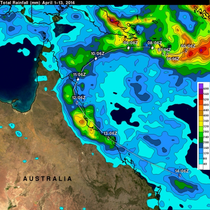
This TRMM satellite rainfall map covers Tropical Cyclone Ita's life from April 1-14. Highest isolated rainfall was estimated around 400 mm/15.7 inches west of both Ingham and Townsville, Queensland. Ita's locations at 0600 UTC are shown overlaid in white. Image Credit: SSAI/NASA/JAXA, Hal Pierce
TRMM is a satellite managed by both NASA and JAXA, the Japan Aerospace Exploration Agency. At NASA's Goddard Space Flight Center in Greenbelt, Md. Hal Pierce created a TRMM-based near-real time Multi-satellite Precipitation Analysis (TMPA).
The TMPA precipitation data covered the period from April 1 to 14, 2014 which starts when Ita formed in the Coral Sea and moved along northeastern Australia's coast. This TRMM satellite rainfall map estimated that some of the largest isolated rainfall totals were near 400 mm/15.7 inches west of both Ingham and Townsville, Queensland.
A 3-D image of Ita was made at NASA using data collected by the TRMM satellite on April 14, 2014 at 0416 UTC/12:16 a.m. EDT after the tropical storm moved back into the Coral Sea.
TRMM's Precipitation Radar (PR) instrument found that the weakening tropical cyclone was still dropping rainfall at a maximum rate of over 161 mm/6.3 inches per hour over the Coral Sea. The 3-D image, created using TRMM PR data, showed that some storms within Ita were still reaching heights of over 13 km/8 miles as it was becoming extra-tropical.
Another NASA-shared satellite captured a visible look at Ita's remnants on April 15. The Visible Infrared Imaging Radiometer Suite (VIIRS) instrument aboard NASA-NOAA's Suomi NPP satellite captured a look at the dying extra-tropical storm. VIIRS collects visible and infrared imagery and global observations of land, atmosphere, cryosphere and oceans.
When Suomi flew over Extra-Tropical Storm Ita on April 15 at 3:53 UTC/April 14 at 11:53 p.m. EDT, VIIRS visible data revealed that Ita's structure had elongated more than the previous day. The VIIRS image showed that strong northwesterly wind shear continued to hammer the storm because the bulk of the storm's clouds were pushed southeast of the center. Ita's remnants have taken on more of a frontal appearance today as they continue to weaken at sea.
Text credit: Hal Pierce / Rob Gutro
NASA's Goddard Space Flight Center
Media Contact
More Information:
http://www.nasa.gov/content/goddard/ita-southern-pacific-ocean/All latest news from the category: Earth Sciences
Earth Sciences (also referred to as Geosciences), which deals with basic issues surrounding our planet, plays a vital role in the area of energy and raw materials supply.
Earth Sciences comprises subjects such as geology, geography, geological informatics, paleontology, mineralogy, petrography, crystallography, geophysics, geodesy, glaciology, cartography, photogrammetry, meteorology and seismology, early-warning systems, earthquake research and polar research.


Newest articles

Microscopic basis of a new form of quantum magnetism
Not all magnets are the same. When we think of magnetism, we often think of magnets that stick to a refrigerator’s door. For these types of magnets, the electronic interactions…

An epigenome editing toolkit to dissect the mechanisms of gene regulation
A study from the Hackett group at EMBL Rome led to the development of a powerful epigenetic editing technology, which unlocks the ability to precisely program chromatin modifications. Understanding how…

NASA selects UF mission to better track the Earth’s water and ice
NASA has selected a team of University of Florida aerospace engineers to pursue a groundbreaking $12 million mission aimed at improving the way we track changes in Earth’s structures, such…

