NASA sees Tropical Cyclone Garry continue to intensify
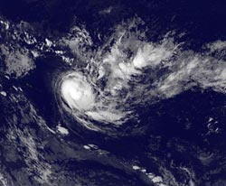
NOAA's GOES-15 satellite captured this infrared image of Tropical Storm Garry about 330 miles east of Pago Pago, American Samoa. The image was taken Jan. 24 at 1500 UTC (10 a.m. EST). The bright white circle of clouds are strong thunderstorms wrapping around the center of circulation as Garry continues to intensify.<br><br>Credit: NASA's GOES Project<br>
NOAA's GOES-15 satellite captured an infrared image of Tropical Storm Garry when it was located about 330 nautical miles (379.8 miles/ 611.2 km) east of Pago Pago, American Samoa. The image, created by the NASA GOES Project at the NASA Goddard Space Flight Center in Greenbelt, Md., was taken Jan. 24 at 1500 UTC (10 a.m. EST).
The image showed a bright white circle of clouds that indicate strong thunderstorms were wrapping around the center of circulation as Garry continues to intensify. The latest bulletin from the Joint Typhoon Warning Center noted that microwave satellite imagery confirmed deep convection wrapping almost entirely around Garry's well-defined low level circulation center.
NOAA's GOES-15 satellite is in a fixed orbit over the Pacific Ocean, midway between Hawaii and the West Coast and 22,300 miles above the equator. GOES-15 provides a good view of what is happening in U.S. west and in the Pacific Ocean.
On Jan. 24 at 0900 UTC, Garry's maximum sustained winds had increased to 60 knots (69 mph/111.1 kph). Garry's tropical-storm-force winds extend about 55 nautical miles (63.3 miles/102 km) from the center, making it a compact tropical cyclone. It was centered near 14.0 south latitude and 164.9 west longitude and moving to the southeast at 11 knots (12.6 mph/20.3 kph).
Forecasters at JTWC expect that Garry will continue moving southeast and is expected to pass far south of French Polynesia. Garry is expected to briefly reach cyclone (hurricane) strength before wind shear weakens and dissipates the storm.
Media Contact
More Information:
http://www.nasa.govAll latest news from the category: Earth Sciences
Earth Sciences (also referred to as Geosciences), which deals with basic issues surrounding our planet, plays a vital role in the area of energy and raw materials supply.
Earth Sciences comprises subjects such as geology, geography, geological informatics, paleontology, mineralogy, petrography, crystallography, geophysics, geodesy, glaciology, cartography, photogrammetry, meteorology and seismology, early-warning systems, earthquake research and polar research.


Newest articles

Why getting in touch with our ‘gerbil brain’ could help machines listen better
Macquarie University researchers have debunked a 75-year-old theory about how humans determine where sounds are coming from, and it could unlock the secret to creating a next generation of more…

Attosecond core-level spectroscopy reveals real-time molecular dynamics
Chemical reactions are complex mechanisms. Many different dynamical processes are involved, affecting both the electrons and the nucleus of the present atoms. Very often the strongly coupled electron and nuclear…

Free-forming organelles help plants adapt to climate change
Scientists uncover how plants “see” shades of light, temperature. Plants’ ability to sense light and temperature, and their ability to adapt to climate change, hinges on free-forming structures in their…

