River
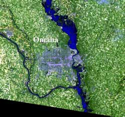
Landsat 5 captures Missouri River flooding near Omaha
The Landsat 5 image captured was an enlargement of the area just north of Omaha. The flood waters show up as very dark blue and, where the water is shallow,…
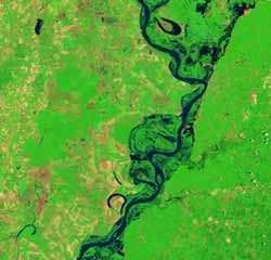
Landsat Satellite Images Reveal Extent of Historic North Dakota Flooding
The Landsat 5 satellite captured the top image on May 16, 2011, before the flooding began. It shows the Souris River within its banks. The Souris River flows…
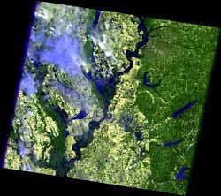
Landsat 5 satellite sees Mississippi River floodwaters lingering
On May 19, 2011, the Mississippi River reached a historic crest at Vicksburg. According to the Advanced Hydrological Prediction Service (AHPS) of the U.S….

Jellyfish blooms transfer food energy from fish to bacteria
Jellyfish can be a nuisance to bathers and boaters in the Chesapeake Bay on the United States' East Coast and many other places along the world's coasts.A new…
Modeling the Mississippi: LSU Researchers Study Methods to Use River Sediment to Repair the Coast
As the already gargantuan body of water swells beyond its normal manmade boundaries, the state of Louisiana is starting to see impact after having seen the…
Satellite images display extreme Mississippi River flooding from space
The flood crest of 47.87 feet on May 10, is the second highest rise in recent history; the highest being 48.7 feet in 1937. Five counties surrounding Memphis…