Earth Sciences
Earth Sciences (also referred to as Geosciences), which deals with basic issues surrounding our planet, plays a vital role in the area of energy and raw materials supply.
Earth Sciences comprises subjects such as geology, geography, geological informatics, paleontology, mineralogy, petrography, crystallography, geophysics, geodesy, glaciology, cartography, photogrammetry, meteorology and seismology, early-warning systems, earthquake research and polar research.

Mars May Be Much Older – or Younger – than Thought, According to Research by UB Planetary Geologist
Analysis of Martian volcanoes will help determine when Hesperian epoch began
Research by a University at Buffalo planetary geologist suggests that generally accepted estimates about the geologic age of surfaces on Mars — which influence theories about its history and whether or not it once sustained life — could be way off.
Funded by the National Aeronautics and Space Administration, the research eventually could overturn principles about the relative ages of different are
Earth Scientists Forge New Understanding of Mountain-Building Dynamics
Understanding how mountains form is critically important — from volcanic eruptions to earthquakes to catastrophic mudslides, the geologic processes active in mountain belts affect human societies every day. Yet, even though mountains are on all continents and in all ocean basins, scientists still understand relatively little about the forces that interact to form and destroy mountains, how mountains change over time, and the relationship between mountains and Earth’s climate.
To better
Long-lost records confirm rising sea level
The discovery of 160 year old records in the archives of the Royal Society, London, has given scientists further evidence that Australian sea levels are rising.
Observations taken at Tasmania’s Port Arthur convict settlement 160 years ago by an amateur meteorologist have been compared with data from a modern tide gauge.
“There is a rate of sea level rise of about 1mm a year, consistent with other Australian observations,” says Dr David Pugh, from the UK’s Southampton Ocean
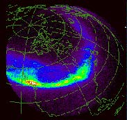
Magnetic ’slinky effect’ may power aurora
The spectacular aurora borealis displays that light up the northern nights could be powered by a gigantic “slinky” effect in Earth’s magnetic field lines, according to research performed at the University of Minnesota. Earth’s magnetic field resemble a slinky in that when “wiggled,” it undulates in waves that travel down the field lines at speeds up to 25 million miles per hour. These waves can pass energy to electrons, accelerating them along the magnetic field lines toward Earth. When the
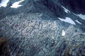
Scientists explain formation of stone circles and other strange patterns in northern regions
Mysterious patterns arise through simple feedback mechanisms and self-organization
Perfect circles of stones cover the ground in parts of Alaska and the Norwegian islands of Spitsbergen. Elsewhere in the far north, stones form other striking patterns on the ground: polygons, stripes, islands, and labyrinths. No, pranksters are not at work in these remote areas, nor are aliens, elves, or any other outside forces moving the stones around. According to scientists who have studied the phe
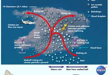
NASA scientists take first ’full-body scan’ of evolving thunderstorm
A doctor gets a better view inside a patient by probing the body with CAT and MRI scanning equipment. Now, NASA meteorologists have done a kind of “full-body scan” of an evolving thunderstorm in the tropics, using advanced radar equipment to provide a remarkable picture of the storm’s anatomy. The observations are expected to help double-check satellite rainfall measurements, improve computer models of storms, and make the skies safer for airplanes to navigate.
David Atlas of NASA’s Goddar