Earth Sciences
Earth Sciences (also referred to as Geosciences), which deals with basic issues surrounding our planet, plays a vital role in the area of energy and raw materials supply.
Earth Sciences comprises subjects such as geology, geography, geological informatics, paleontology, mineralogy, petrography, crystallography, geophysics, geodesy, glaciology, cartography, photogrammetry, meteorology and seismology, early-warning systems, earthquake research and polar research.
Ground temperature aids in measuring water levels
Scientists are studying water tables in the Southwest with an eye towards conservation
Scientists have discovered an unusual way to measure how fast water moves from the ground surface to the water table: they analyze the ground temperature.
Research in Vadose Zone Journal, published by the Soil Science Society of America, describes the methodology behind using temperature to analyze how much water is recharging the ground water at a specific location. The research describes
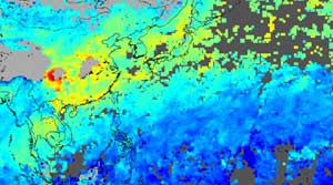
New Images from Space Spotlight Asian, Australian Pollution
A visualization of satellite data captured and processed January 1–20, 2003, by scientists at the National Center for Atmospheric Research (NCAR) shows heavy pollution from China and Southeast Asia blowing out over the Pacific Ocean. The near-real time capability represented by the image is a breakthrough for NCAR team members working with the Measurements of Pollution in the Troposphere (MOPITT) instrument aboard NASA’s Terra satellite.
The image shows levels of carbon monoxide (CO) in a
NASA satellite helps scientists see effects of earthquakes in remote areas
The unique capabilities of a NASA earth-observing satellite have allowed researchers to view the effects of a major earthquake that occurred in 2001 in Northern India near the border of Pakistan.
Lead author Bernard Pinty of the Institute for Environment and Sustainability in the Joint Research Centre of the European Commission, Ispra, Italy, and colleagues from the U.S., France and Germany, used the Multi-angle Imaging SpectroRadiometer (MISR) instrument on NASA’s Terra satellite to o
Volcanic seamounts siphon ocean water through the seafloor
Researchers trace flow over long distances
Researchers have discovered a pair of seamounts on the ocean floor that serve as inflow and outflow points for a vast plumbing system that circulates water through the seafloor. The seamounts are separated by more than 30 miles (52 kilometers).
“One big underwater volcano is sucking in seawater, and the water flows north through the rocks of the seafloor and comes out through another seamount,” said Andrew Fisher, an associate professor
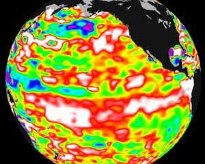
cean surface saltiness influences el nino forecasts
NASA sponsored scientists have discovered by knowing the salt content of the ocean’s surface, they may be able to improve the ability to predict El Nino events. Scientists, studying the western Pacific Ocean, find regional changes in the saltiness of surface ocean water correspond to changes in upper ocean heat content in the months preceding an El Nino event. Knowing the distribution of surface salinity may help predict events.
Salinity and temperature combine to dictate the ocean’s dens
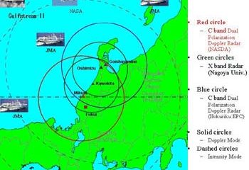
NASA Joins Snow Study Over The Sea Of Japan
NASA and two Japanese government agencies are collaborating on a snowfall study over Wakasa Bay, Japan. Using NASA’s Earth Observing System Aqua satellite, research aircraft and coastal radars to gather data, the joint effort is expanding scientific knowledge about where precipitation falls.
Until now, the north Pacific’s contributions to the global hydrologic cycle have been difficult to quantify. Precipitation measurements by satellite over open water are very important, because