Mississippi
Satellite images display extreme Mississippi River flooding from space
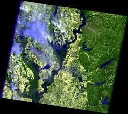
The flood crest of 47.87 feet on May 10, is the second highest rise in recent history; the highest being 48.7 feet in 1937. Five counties surrounding Memphis…
Study Probes Sources of Mississippi River Phosphorus
But according to new modeling research that examined phosphorus loading from all 1768 counties in the Mississippi River Basin (MRB), the true causes aren’t…
Seeds of Gulf Dead Zones Are Draining from U.S. Farms
A study recently published in the Journal of Environmental Quality by a team from Cornell University and the University of Illinois-Urbana found that tile…
At Great Expense, Railroad Bypassed First U.S. Black-founded Town
The bypass pushed what would have been a fairly straight, even run of railroad tracks from Griggsville, Ill. to Hannibal, Mo., in a wide, hilly arc around New…
Cilia revolution
While the new material isn't exactly like cilia, it responds to thermal, chemical, and electromagnetic stimulation, allowing researchers to control it and…
NOAA-Supported Scientists Predict “Larger Than Average” Gulf Dead Zone
Scientists are predicting the area could measure between 6,500 and 7,800 square miles, or an area roughly the size of the state of New Jersey. The average of…