


Feeding 9 Billion: Innovations in Agricultural Modeling
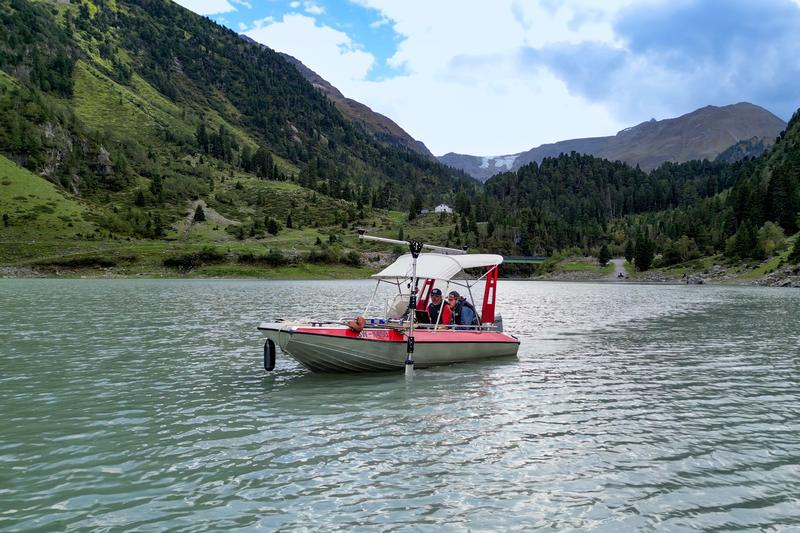
The KU research boat on its first mission.
(c) Dr. Christian Klenk / upd
On land, in the air – and now also by water: Geographers of Catholic University of Eichstätt-Ingolstadt (KU) are broadening the scope of their research. Their equipment now includes a research boat with a high-precision depth sounder. It allows researchers to survey the bottom of lakes, rivers, and the sea. This technology has now been used for the first time in a research project in Kaunertal, Austria, where KU scientists have been studying the effects of climate change for several years.
Dr. Florian Haas, adjunct professor at the Chair of Physical Geography, has taken a seat behind the steering wheel, with research assistant Dr. Manuel Stark at his side. In front of them on a mounted table: a laptop, screens and quite a few technical devices. From there, cables lead to a structure that is attached to the outer wall of the boat and protrudes into the water: the so-called multibeam echo sounder. It emits beam-shaped sound waves into the water and measures the reflections at the lakebed. This allows the researchers to calculate the depth of the water to accurate to the centimeter – not just at one specific point, but over a path several meters wide. The measuring instrument is equipped with a satellite navigation system so that the exact position data is stored together with the measured values. When tracing a body of water systematically in paths, you obtain a detailed underwater terrain model. Florian Haas pushes the throttle of the engine forward, the aluminum boat with the two researchers accelerates and heads for the middle of the Kaunertal reservoir.

The terrain around the Gepatschferner, the second largest glacier in Austria, has been a popular research destination for geographers for several years. Within the framework of the international project “Sensitivity of High Alpine Geosystems to Climate Change from 1850 onwards” (SEHAG), a research group of the German Research Foundation (DFG) coordinated by the KU is investigating the effects of climate change in the Alpine region on glaciers and rivers, vegetation and geomorphology. In addition to the scientists from Eichstätt, researchers from Bern, Bolzano, Bremen, Munich, Innsbruck and Vienna are also involved. The project reconstructs the changes caused by the melting of the glacier retrospectively for the time since 1850, measures processes currently taking place, and thus attempts to make a forecast as accurate as possible for the time until 2050.
Until now, Haas and his colleagues have mostly been on the glacier on foot. At regular intervals, they use a laser scanner and drone imagery to examine mountain slopes that are becoming unstable as the glacier’s ice recedes. A radar device mounted on a sled is used to measure the thickness of the ice, which is rapidly decreasing due to high temperatures – the length of the Gepatschferner glacier recently decreased by just over 50 meters per year; no other glacier in the Alps is melting so quickly. In addition to exploring the glacier on foot, Florian Haas also regularly travels by helicopter. A laser scanner is mounted to the helicopter to also enable measurements of the terrain surface from the air.
The meltwater leaves the ice surface at its lower end at what is called the glacier gate. In the process, the stream also takes rocks and sediments with it and carries the material down the valley. “For our research on the landscape changes in the mountain massif and in the valley, it is also an important question how much gravel and finer sediments are carried away by the meltwater”, explains Florian Haas. But, as the geographer points out, it was difficult to determine that directly on the glacial stream. A better opportunity is offered in the valley Kaunertal: There, below the glacier, is a water reservoir that was created about 60 years ago by building a dam to produce electricity for the region via a power plant. At the time of its construction, the dam was the tenth highest dam in the world, with a length of 600 meters and a height of over 150 meters, and the water depth of the lake is more than 100 meters in some places.
“Based on data and photographs, we know the terrain profile from the time before the construction of the Gepatsch reservoir and, following a new survey of the lake bed that is now being carried out, we can calculate the quantities of gravel and sediment that the glacial stream has transported into the lake since the water reservoir was commissioned and where the material has been deposited”, explains Florian Haas. From this, an average annual sediment load can be calculated and also forecast into the future. He said this was not only an important missing piece for the SEHAG project, but also a useful finding for the reservoir’s operating company.
In uniform paths – similar to a farmer with a tractor in the field – the KU research boat travels across the entire lake surface. On the screen, Florian Haas can read the information on water depth and can see on a map display which area of the seabed the echo sounder has covered. The technology could also be used for other research projects and locations; for example, surveys are planned in rivers close to barrages. “With this new equipment, we can work on issues related to, for example, the morphology, properties and changes in submerged parts of the Earth’s surface.” Thus, the KU research boat, which was previously used as a fireboat and was acquired second-hand, will be also used in other research projects.
Apl. Prof. Dr. Florian Haas (florian.haas@ku.de)


People’s intuitive assessments of biodiversity based on visual and auditory stimuli are very accurate and closely match science assessments of biodiversity. Based on a new study from the British Ecological Society that came out in the magazine People and Nature. Researchers from the German Centre for Integrative Biodiversity Research (iDiv), the Helmholtz Centre for Environmental Research (UFZ), and Friedrich Schiller University Jena recently did a study where people who had never studied ecology had to sort pictures and sounds of…

The forecast is bright for future, long-term multiband monitoring of planets Imaging data from Japan’s Himawari-8 and -9 meteorological satellites have been successfully used to monitor temporal changes in Venus’ cloud-top temperature, revealing unseen patterns in the temperature structure of various waves. A team led by the University of Tokyo collated infrared images from 2015–25 to estimate brightness temperatures on day to year scales. The results demonstrate that meteorological satellites can serve as additional eyes to access the Venusian atmosphere…

Chipmunk and vole skulls from over 125 years reflect changes in diet and noise exposure In general, evolution is a long, slow process of tiny changes passed down over generations, resulting in new adaptations and even new species over thousands or millions of years. But when living things are faced with dramatic shifts in the world around them, they sometimes rapidly adapt to better survive. Scientists recently found an example of evolution in real time, tucked away in the collection…

Discovery reveals pulsing mantle plume beneath Ethiopia, where a new ocean is forming Research led by Earth scientists at the University of Southampton has uncovered evidence of rhythmic surges of molten mantle rock rising from deep within the Earth beneath Africa. These pulses are gradually tearing the continent apart and forming a new ocean. The findings, published in Nature Geoscience, reveal that the Afar region in Ethiopia is underlain by a plume of hot mantle that pulses upward like a…


