
Experts explore for the first time life on the seafloor in a region formerly covered by thick ice Roughly two weeks ago, a massive iceberg calved from the Antarctic Ice Sheet. As the only research vessel nearby, the Polarstern took the opportunity to enter the area between the iceberg and the Brunt Ice Shelf. The first images from the seafloor reveal an amazing level of biodiversity in a region that was covered by thick ice for decades. The sediment samples…
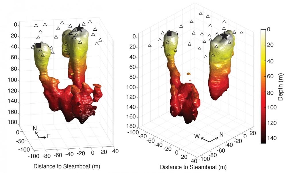
When Steamboat Geyser, the world’s tallest, started erupting again in 2018 in Yellowstone National Park after decades of relative silence, it raised a few tantalizing scientific questions. Why is it so tall? Why is it erupting again now? And what can we learn about it before it goes quiet again? The University of Utah has been studying the geology and seismology of Yellowstone and its unique features for decades, so U scientists were ready to jump at the opportunity to…
High-resolution model reveals new insights With the help of highly resolved realistic model simulations physicists at the Leibniz Institute for Baltic Sea Research (IOW) have succeeded in depicting the so-called submesoscale dynamics in the Eastern Gotland Basin – deepest of the large basins of the central Baltic Sea. Thus, the researchers gained the opportunity to investigate these highly dynamic phenomena, which – although being known for decades through satellite images – are up to now only scarcely studied and poorly…
Water levels in the world’s ponds, lakes and human-managed reservoirs rise and fall from season to season. But until now, it has been difficult to parse out exactly how much of that variation is caused by humans as opposed to natural cycles. Analysis of new satellite data published March 3 in Nature shows fully 57 percent of the seasonal variability in Earth’s surface water storage now occurs in dammed reservoirs and other water bodies managed by people. “Humans have a…
To investigate humans’ impact on freshwater resources, scientists have now conducted the first global accounting of fluctuating water levels in Earth’s lakes and reservoirs – including ones previously too small to measure from space. The research, published March 3 in the journal Nature, relied on NASA’s Ice, Cloud and land Elevation Satellite 2 (ICESat-2), launched in September 2018. ICESat-2 sends 10,000 laser light pulses every second down to Earth. When reflected back to the satellite, those pulses deliver high-precision surface…
Scientists regularly use remote sensing drones and satellites to record how climate change affects permafrost thaw rates — methods that work well in barren tundra landscapes where there’s nothing to obstruct the view. But in boreal regions, which harbor a significant portion of the world’s permafrost, obscuring vegetation can stymy even the most advanced remote sensing technology. In a study published in January, researchers in Germany and at the University of Alaska Fairbanks’ Geophysical Institute developed a method of using…
Stevens uses machine learning-driven techniques to develop a long-awaited tool that better reveals the health of Earth’s oceans and the impacts of climate change. Researchers at Stevens Institute of Technology have developed a new machine learning-powered platform, known as OC-SMART, that can process ocean color in satellite images 10 times faster than the world’s leading platform. The work, which will be adopted by NASA, is one of the first machine learning-based platforms in ocean color analysis that can process both…
During glacial periods, the sea level falls, because vast quantities of water are stored in the massive inland glaciers. To date, however, computer models have been unable to reconcile sea-level height with the thickness of the glaciers. Using innovative new calculations, a team of climate researchers led by the Alfred Wegener Institute has now managed to explain this discrepancy. The study, which was recently published in the journal Nature Communications, could significantly advance research into our planet’s climate history. During…
A new study identifies nine specific large-scale weather patterns that influence extreme precipitation over the Mediterranean. Making use of this connection between localized extremes and large-scale weather variability can help to better predict heavy rainfall up to three weeks ahead. Researchers at the European Centre for Medium-Range Weather Forecasts (ECMWF, UK) and TU Bergakademie Freiberg (Germany) presented their results in the current issue of the International Journal of Climatology. Extreme rainfall has devastating consequences for societies and economies. Locations around…
Tübingen geoscientists show how biological soil crusts prevent soil from being washed away Every year, billions of tons of valuable soil are lost worldwide through erosion, much of it deposited in bodies of water that fill with sand or silt as a result. Soil losses measured in Germany range from 1.4 to 3.2 tons per hectare per year; in extreme weather, the figure can be as high as fifty tons. Geoscientists at the University of Tübingen have now shown how…
Fractured rocks of impact craters have been suggested to be suitable environments for deep colonization of microbial communities. In a new study published in Communications Earth & Environment, a team of researchers shows that fungi has colonized deep parts of the largest impact crater in Europe, the Siljan impact structure, Sweden. Intriguingly, the fungi seem to have been fueling methane production in the crater. At the scenic Swedish lake of Siljan, an impressive impact structure of more than 50 km…
Bremen consortium develops innovative docking system for underwater robots. How can inaccessible places on the Earth, such as the deep sea, as well as those on other planets be investigated? Extreme goals present extreme challenges for the technology used. These are more serious than just corrosion or resistance to unusual pressures. For example, the new technological solutions will enable communication with and supply of energy to underwater robots by way of an innovative docking system. Toward this end, a consortium…
Researchers from the Oil and Gas Research Institute of the Russian Academy of Sciences and their Skoltech colleagues have surveyed the newest known 30-meter deep gas blowout crater on the Yamal Peninsula, which formed in the summer of 2020. The paper was published in the journal Geosciences. Giant craters in the Russian Arctic, thought to be the remnants of powerful gas blowouts, first attracted worldwide attention in 2014, when the 20 to 40-meter wide Yamal Crater was found quite close…
Geologists have developed a new theory about the state of Earth billions of years ago after examining the very old rocks formed in the Earth’s mantle below the continents. Assistant Professor Emma Tomlinson from Trinity College Dublin and Queensland University of Technology’s Professor Balz Kamber have just published their research in leading international journal, Nature Communications. The seven continents on Earth today are each built around a stable interior called a craton, and geologists believe that craton stabilisation some 2.5…
Scientists from Alfred Wegener Institute: “We need to have a fresh look at the role of the Arctic Ocean.” The Arctic Ocean was covered by up to 900 m thick shelf ice and was filled entirely with freshwater at least twice in the last 150,000 years. This surprising finding, reported in the latest issue of the journal Nature, is the result of long-term research by scientists from the Alfred Wegener Institute and the MARUM. With a detailed analysis of the…
An upsurge of matter from deep beneath the Earth’s crust could be pushing the continents of North and South America further apart from Europe and Africa, new research has found. The plates attached to the Americas are moving apart from those attached to Europe and Africa by four centimetres per year. In between these continents lies the Mid-Atlantic Ridge, a site where new plates are formed and a dividing line between plates moving to the west and those moving to…
 Feedback


