
On Wednesday, September 3, the National Hurricane Center (NHC) issued a Tropical Storm Warning from La Paz to Santa Fe, Mexico. There is also a Tropical Storm…
The MODIS or Moderate Resolution Imaging Spectroradiometer instrument aboard NASA's Terra satellite took an image of Tropical Storms Norbert in the Eastern…
The seamount was discovered in August when James Gardner, research professor in the UNH-NOAA Center for Coastal and Ocean Mapping/Joint Hydrographic Center,…
Global climate trend since Nov. 16, 1978: +0.14 C per decade
How do you prevent an earthquake from destroying expensive computer systems?
However, current methods of acquisition are costly and require trained personnel with high-tech, cumbersome equipment. In light of this, Kendra Johnson and…
In July of 2008, Tropical Storm Dolly made landfall on Mexico's Yucatan Peninsula of Mexico before making a second and final landfall in south Texas. Now, six…
Water scarcity is not a problem just for the developing world. In California, legislators are currently proposing a $7.5 billion emergency water plan to their…
“It's very important to consider this scenario of earthquakes, occurring possibly seconds apart, one immediately after another,” said co-author Anna Tramelli,…
Experts defend operational earthquake forecasting (OEF) in an editorial published in the Seismological Research Letters (SRL), arguing the importance of public…
Researchers at the University of Southampton detected the rapid rise in sea-level by studying satellite scans of a region that spans more than a million square…
NOAA's GOES-West satellite captured an image of Marie on August 28 at 11 a.m. EDT. Bands of thunderstorms circled the storm especially to the north.
NASA's airborne Hurricane and Severe Storm Sentinel, or HS3, mission returns to NASA Wallops for the third year to investigate the processes that underlie…
NASA's Tropical Rainfall Measuring Mission or TRMM satellite flew above Hurricane Cristobal on August 26 at 11:35 UTC (7:35 a.m. EDT) gathering rainfall data….
Most of North America’s megafauna — mastodons, short-faced bears, giant ground sloths, saber-toothed cats and American camels and horses — disappeared…
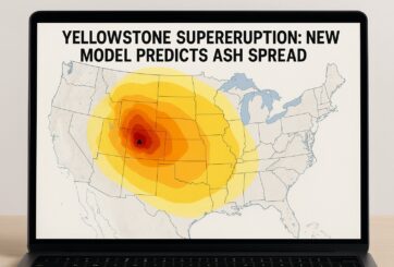
An improved computer model developed by the study’s authors finds that the hypothetical, large eruption would create a distinctive kind of ash cloud known as…
 Feedback


