
Odile had weakened to a tropical storm with winds of about 55 knots (63.3 mph) when the TRMM satellite flew over on September 16, 2014 at 0917 UTC (2:19 a.m….
NASA's airborne Hurricane and Severe Storm Sentinel, or HS3, mission kicked off on August 26 when one of the remotely piloted Global Hawk aircraft flew a…
NASA’s Cloud Physics Lidar (CPL) instrument, flying aboard an unmanned Global Hawk aircraft in this summer’s Hurricane and Severe Storm Sentinel, or HS3,…
Applying biomechanical formulas to a treasure trove of thousands of fossilized leaves of angiosperms — flowering plants excluding conifers — the team was able…
Tornado records from Nebraska, Kansas, Oklahoma, and northern Texas – an area of high tornado activity dubbed “Tornado Alley” — show that peak tornado activity…
The area of sea ice in the Arctic fell to a summer minimum of around 5.0 million square kilometres this year, which is about 1.6 million square kilometres more…
Odile made landfall near Cabo San Lucas at 0445 UTC (12:45 a.m. EDT) and was moving northwest along the length of the peninsula of Baja California, then…
Scientists thought the climate pattern known as the Asian monsoon began 22-25 million years ago as a result of the uplift of the Tibetan Plateau and the…
The finding of a ‘cell-like’ structure, which investigators now know once held water, came about as a result of collaboration between scientists in the UK and…
Planet Venus, with its thick atmosphere made of carbon dioxide, its parched surface, and pressures so high that landers are crushed within a few hours, offers…
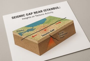
When a segment of a major fault line goes quiet, it can mean one of two things: The “seismic gap” may simply be inactive — the result of two tectonic plates…
The Atmospheric Infrared Sounder or AIRS instrument that flies aboard NASA's Aqua satellite captured infrared data on Tropical Depression 15-E on September 10…
NASA's Aqua satellite passed over Tropical Storm Fengshen on September 7 and the Atmospheric Infrared Sounder instrument known as AIRS gathered temperature…
The MODIS instrument or Moderate Resolution Imaging Spectroradiometer aboard NASA's Terra satellite captured a visible picture of Tropical Storm Norbert on…
NASA's Aqua satellite captured the remnants of Tropical Depression Dolly over northeastern Mexico on Sept. 3 at 19:40 UTC (3:40 p.m. EDT). The image, captured…
These are findings of a new study that looked at the agricultural effects in 2005 of high concentrations of ground-level ozone, a plant-damaging pollutant…
 Feedback


