


Feeding 9 Billion: Innovations in Agricultural Modeling
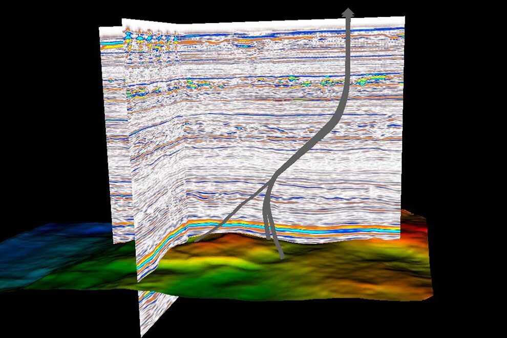
Typical seismic subsurface representation with borehole paths and the surface of a rock layer. Data provided by Equinor and the Volve license partners.
© Equinor Open Data License
The seismic reflection method involves sending acoustic waves thousands of meters under the Earth’s surface.
The reflected signals provide scientists with information about the characteristics of the subsurface. This is how oil and gas deposits can be discovered. While these will eventually no longer be extracted as we move away from fossil fuels, accurate knowledge of rock structures is important for better understanding known reservoirs. The Earth’s subsurface could be a key place to store greenhouse gases. With improved machine learning algorithms and new high-performance computing concepts, researchers at the Fraunhofer ITWM are now able to process seismic data in greater detail.
Seismic reflection is an efficient, non-destructive method of exploring the subsurface and amongst other applications is used to search for oil, gas and hot water reservoirs. It involves transmitting acoustic waves into the ground and recording the signals reflected back. The results indicate the composition and structure of the subsurface, helping to locate reservoirs. The technology works on land as well as offshore on areas within the continental shelf. The key to producing meaningful results is the processing and analysis of the data recorded. The Fraunhofer Institute for Industrial Mathematics ITWM in Kaiserslautern has further developed the data processing method. With this improved seismic imaging, the raw data undergoes multiple processing stages to create an extremely detailed image of the seabed and its complex subsurface structure.
Fraunhofer experts are using the SF GRT (Statoil Fraunhofer “Generalized Radon Transform”) process developed during contract research. Dr. Norman Ettrich, one of the section heads for High-Performance Computing and Seismic team leader, and his team have used innovative machine learning (ML) algorithms to refine the software package to a higher level of detail and optimized the underlying computer architecture. It now provides detailed and precise images of rock structures under the seabed. This makes it possible to identify the size, structure and shape of oil and gas reservoirs under the surface — to within a few meters of accuracy. For this project, Fraunhofer ITWM pooled its expertise in geophysics, mathematics and information technology.
Discovering new oil and gas deposits under the seabed is by no means the main focus, though. Norman Ettrich explains: “Due to the move away from fossil fuels, there is waning interest from European countries in discovering new oil and gas deposits. They are more concerned with better understanding and examining known reservoirs and those already in use.” After all, the technology can also be used to find suitable locations for greenhouse gases such as CO2 to be deposited underground.
Researching the surface and subsurface of the seabed requires specialist ships that often cover thousands of square kilometers in straight lines. They drag airguns and hydrophones behind them. Typically, the airguns send an acoustic pulse down every 25 meters. In the water, the sound waves travel at a speed of 1,480 m/s, penetrating the rock layers under the seabed. In extreme cases, the acoustic waves can travel through 3,000 meters of water, before passing through another 11,000 meters below the seabed.
The signals reflected are then detected on the sea surface by highly sensitive hydrophones. “In this way, each pulse creates a seismic trace. These traces provide information about how much time elapses between emission and reception. This propagation time is also influenced by the composition and size of each rock layer. Because the acoustic signal is picked up by multiple hydrophones, the seabed can be analyzed from multiple angles. The strength, propagation time and angle of the signal provide crucial information about the features, structure and thickness of the rock formation. This includes information about whether a particular layer is very porous and whether the pores are filled with oil or gas, for example.
During a typical exploration, a specialist vessel will travel along hundreds of parallel lines across the area to be investigated. Along each line, thousands of airgun pulses are emitted, and each pulse is captured as a reflected signal by thousands of hydrophones. The result of this is hundreds of millions of data traces collected, which amounts to numerous terabytes of information. To manage this enormous quantity of data, computing experts in Kaiserslautern have developed special high-performance computing (HPC) concepts (see box).
The data are first filtered, edited and presorted, then the subsurface can be mapped out using the seismic migration method. To improve data processing quality further after migration, more and more fully automated ML processing algorithms are being introduced. “The particular strength of our method, which is enhanced by ML algorithms, is that it no longer uses abstractions in the analysis of the data that would end up compromising the accuracy of the analysis,” explains Ettrich. The result being a detailed visual representation of the complex subsurface structure.
The optimizations make it possible for the first time to detect diffraction or fault zones and render them visible in the image created. These are relatively small areas in which the characteristics of a rock layer change suddenly, for example by the occurrence of faults in an otherwise sealing layer. “This would indicate an area from which oil or gas has long since escaped. It could also indicate that the layer is too porous to function as a CO2 reservoir or that a hot water reservoir is present and the formation would therefore be suitable for geothermal systems,” Ettrich continues.
Identifying such diffraction objects with the seismic reflection method can also be very useful for wind turbine placement in offshore wind parks. The Fraunhofer technology analyzes the subsurface, thereby flagging sites with particularly hard rock that would hinder the installation of the turbine mast in the seabed. This helps to avoid expensive problems later on.
https://www.fraunhofer.de/en/press/research-news/2023/march-2023/seismic-imaging…


A new quantum random number generator is almost 1000 times faster than other generators and much smaller, promising to change data management and cybersecurity in several industries including health, finance, and defense A joint team of researchers led by scientists at King Abdullah University of Science and Technology (KAUST) and King Abdulaziz City for Science and Technology (KACST) has reported the fastest quantum random number generator (QRNG) to date based on international benchmarks. The QRNG, which passed the required randomness…

Very secure and highly efficient: encryption and decryption with luminescent perovskites To guarantee high data security, encryption must be unbreakable while the data remains rapidly and easily readable. A novel strategy for optical encryption/decryption of information has now been introduced in the journal Angewandte Chemie by a Chinese research team. It is based on compounds with carefully modulated luminescent properties that change in response to external stimuli. The compounds are hybrid two-dimensional organic-inorganic metal-halide perovskites, whose structure consists of inorganic…

Researchers at the University of Utah’s Department of Psychiatry and Huntsman Mental Health Institute today published a paper introducing RiskPath, an open source software toolkit that uses Explainable Artificial Intelligence (XAI) to predict whether individuals will develop progressive and chronic diseases years before symptoms appear, potentially transforming how preventive healthcare is delivered. XAI is an artificial intelligence system that can explain complex decisions in ways humans can understand. The new technology represents a significant advancement in disease prediction and prevention…

Researchers train AI to predict if and why proteins form sticky clumps, a mechanism linked to 50 human diseases affecting half a billion people An AI tool has made a step forward in translating the language proteins use to dictate whether they form sticky clumps similar to those linked to Alzheimer’s Disease and around fifty other types of human disease. In a departure from typical “black-box” AI models, the new tool, CANYA, was designed to be able to explain its…


