Cheap and effective monitoring of glacier discharge

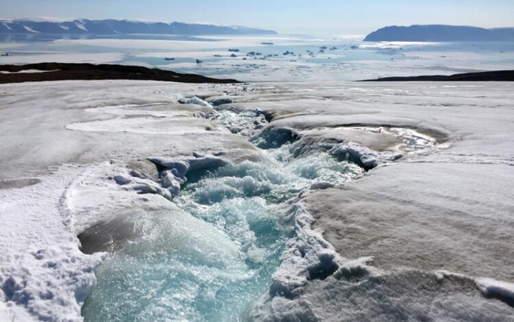
Qaanaaq Glacier, Greenland
Photo: Evgeny Podolskiy
Acoustic signals can be effectively used for monitoring glacial runoff and provide a cheaper and more accessible alternative to existing methods.
Glaciers have been melting and shrinking at an alarming rate, raising the sea-level and causing outburst floods. Scientists are monitoring this change to gauge the meltwater contribution to the ocean and freshwater resources across the globe while also keeping an eye on the risk of glacial flooding. However, glacio-hydrological monitoring is a luxury not every country can afford. The process requires either a substantial effort by observers or sophisticated technology with large volumes of data.
A team of scientists from Hokkaido University led by Evgeny A. Podolskiy, has proposed a safe, affordable, and effective approach for monitoring glacial discharge using sounds generated at the proglacial run-off site. The method, published in the journal Geophysical Research Letters, is not only ~100 times cheaper than the most novel methods but also non-invasive, quick and easily deployable, and can become a tool for long-term glacier monitoring.
Previous research, including that from the team, linked inaudible (infrasound) signals to glacial runoffs, noting a daily variation in the recordings and a peak during the summer. It was hypothesized that these signals might be generated by the radiation of air-pressure waves from the glacial runoff. Consequently, it was suggested that glacier discharge could be measured by analyzing the audible sounds that are also emitted by melting glaciers.
The team of researchers conducted the first near-source study at Qaanaaq Glacier, Greenland, that showed acoustic noise levels scale with proglacial discharge, with an easy-to-detect, audible diurnal pattern. “The ambient sound could be described as a continuous hum of roaring water, which would be familiar to anyone who walked near a white water,” said Podolskiy.
For recording the ambient soundscape, the team deployed a commercially available bird-song recorder near the terminus of the Qaanaaq Glacier. “We estimated the proglacial discharge by water-depth and flow-speed measurements, which were collected at the intersectional site of the proglacial stream and the road between Qaanaaq and the local airport. The acoustic data was analyzed and the result was then cross-correlated with the discharge in order to single out a frequency band that was the best proxy for the proglacial stream,” explains Podolskiy.
The highest correlation was seen in the frequency range of 50–375 Hz. The scientists also found that the noise level clearly mimicked the temporal variation in runoff. Moreover, they observed that the acoustic signal was recorded ~50 minutes before a corresponding change in discharge.
The study demonstrated that audible acoustic signals can be used for sensing glacio-hydrological variations remotely and continuously. The method reduces the risk of instrument loss and does not require avant-garde data processing techniques. Although it does not provide the high spatial resolution of fiber-optic tools that are currently used, it breaks new ground in terms of affordability and overall simplicity. This method can be used to set up early-warning systems to timely detect events like glacier lake outbursts and help mitigate glacial flooding events.
The team acknowledges that the sound-discharge relationships in glaciated watersheds may be complex. Future efforts might benefit from a long-term monitoring, clarified relationship between audible and inaudible sounds, as well as assessed interference effects of wind.
Journal: Geophysical Research Letters
DOI: 10.1029/2023GL103235
Method of Research: Data/statistical analysis
Subject of Research: Not applicable
Article Title: Acoustic Sensing of Glacial Discharge in Greenland
Article Publication Date: 26-Apr-2023
All latest news from the category: Earth Sciences
Earth Sciences (also referred to as Geosciences), which deals with basic issues surrounding our planet, plays a vital role in the area of energy and raw materials supply.
Earth Sciences comprises subjects such as geology, geography, geological informatics, paleontology, mineralogy, petrography, crystallography, geophysics, geodesy, glaciology, cartography, photogrammetry, meteorology and seismology, early-warning systems, earthquake research and polar research.
Newest articles

High-energy-density aqueous battery based on halogen multi-electron transfer
Traditional non-aqueous lithium-ion batteries have a high energy density, but their safety is compromised due to the flammable organic electrolytes they utilize. Aqueous batteries use water as the solvent for…

First-ever combined heart pump and pig kidney transplant
…gives new hope to patient with terminal illness. Surgeons at NYU Langone Health performed the first-ever combined mechanical heart pump and gene-edited pig kidney transplant surgery in a 54-year-old woman…

Biophysics: Testing how well biomarkers work
LMU researchers have developed a method to determine how reliably target proteins can be labeled using super-resolution fluorescence microscopy. Modern microscopy techniques make it possible to examine the inner workings…


