
In the clouds above Darwin, Australia, pilots guided by a team of international climate scientists are now one week into a series of carefully orchestrated flights to obtain key in situ data about tropical clouds. Preliminary results obtained from instrumentation on the Proteus –a space-age aircraft equipped with a suite of highly sophisticated sensors — reveal superior images of ice crystals in high-altitude tropical cirrus clouds.
“These images, combined with data from other air
If the world continues to burn greenhouse gases, California may have an increased risk of winter floods and summer water shortages, even within the same year. This scenario may be more severe in future El Niño years.
New research by Lawrence Livermore National Laboratory (LLNL) scientists shows that global warming is likely to change river flows in ways that may result in both increased flood risk and water shortages. The predictions assume atmospheric carbon dioxide concentratio
When Hurricane Katrina made landfall in August 2005, it changed the look of some of the coastlines of three U.S. states. Now, using Google Earth’s software on the Internet, people can see the before and after affects, thanks to detailed images from NASA and the U.S. Geological Survey (USGS).
The images on Google Earth show changes that Hurricane Katrina made to the Gulf coast from Panama City, Fla. to New Orleans, La.
Hurricane Katrina made landfall in south Plaquemines Par
Researchers at Yale and the University of Washington report that great earthquakes, like the 2004 Sumatra earthquake, may be caused by the build up of sediment on top of subduction zones, suggesting a new way to forecast these most severe earthquakes.
Subduction zones are the boundaries where two tectonic plates collide — one plate pushes over and one pushes under the other. The most severe earthquakes in recent history — in Indonesia in 2004, Alaska in 1964, Chile in 1960 an
UCLA paleobiologist J. William Schopf and colleagues have produced 3-D images of ancient fossils — 650 million to 850 million years old — preserved in rocks, an achievement that has never been done before.
If a future space mission to Mars brings rocks back to Earth, Schopf said the techniques he has used, called confocal laser scanning microscopy and Raman spectroscopy, could enable scientists to look at microscopic fossils inside the rocks to search for signs of life, such as
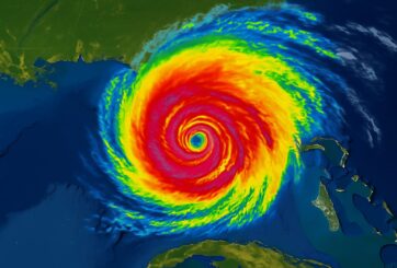
Using a fleet of NASA and other satellites as well as aircraft and other observations, scientists were able to unlock the secret of Hurricane Lili’s unexpected, rapid weakening as she churned toward a Louisiana landfall in 2002. The data from multiple satellites enabled researchers to see dry air move into the storm’s low levels, partially explaining why Lili weakened rapidly.
This study focuses on the rapid weakening of Hurricane Lili over the Gulf of Mexico beginning early on
The most powerful earthquakes – such as those that shook Indonesia in 2004, Alaska in 1964, Chile in 1960 and the Pacific Northwest in 1700 – occur in subduction zones, areas of the sea floor just offshore where two tectonic plates meet and one dives beneath the other.
But not all subduction zones are created equal, and University of Washington researchers believe they have found a key to determine which subduction zones – or which specific areas within a subduction zone – migh
University of Minnesota associate professor of chemical engineering Renata Wentzcovitch and her team of researchers have confirmed the properties of a mineral (post-perovskite) that may form near the Earth’s core in a layer called the D’’ region. The work offers new insight for interpreting properties of this region. The D’’ (Dee double prime) layer surrounds Earth’s core and is between 0 and 186 miles thick. It is at the interface between two chemically distinct regions, the rocky mantle and t
An ambitious ESA project to chart ten years in the life of the Earth’s vegetation has reached a midway point, with participants and end-users having met to review progress so far. Harnessing many terabytes of satellite data, the GLOBCARBON project is intended to hone the accuracy of climate change forecasting.
GLOBCARBON involves the development of a service to generate fully calibrated estimates of land products based on a variety of Earth Observation data, suitable for a
Hurricanes can completely re-structure themselves inside, and that presents forecasters with great uncertainty when predicting their effects on the general population.
Recently, scientists used data from NASA’s Tropical Rainfall Measuring Mission (TRMM) satellite to analyze transformations that take place inside a hurricane. Stephen Guimond, a graduate research assistant at Florida State University, Tallahassee, Fla., lead a study that used TRMM data to view the height at which i
One of the paradoxes of recent explorations of the Martian surface is that the more we see of the planet, the more it looks like Earth, despite a very big difference: Complex life forms have existed for billions of years on Earth, while Mars never saw life bigger than a microbe, if that.
“The rounded hills, meandering stream channels, deltas and alluvial fans are all shockingly familiar,” said William E. Dietrich, professor of earth and planetary science at the University of Ca
Two new studies by a University of Rochester researcher show that mountain ranges rise to their height in as little as two million years–several times faster than geologists have always thought. Each of the findings came from two pioneering methods of measuring ancient mountain elevations, and the results are in tight agreement.
The research papers, appearing in today’s issue of Science and next week’s issue of Earth and Planetary Science Letters, mean scientists will
Ancient water bodies may contain ecosystems adapted to life beneath more than two miles of ice
The Earth Institute at Columbia University–Lying beneath more than two miles of Antarctic ice, Lake Vostok may be the best-known and largest subglacial lake in the world, but it is not alone down there. Scientists have identified more than 145 other lakes trapped under the ice. Until now, however, none have approached Vostok’s size or depth.
In the February 2006 issue of
Scientists May Soon Have Evidence for Exotic Predictions of String Theory
Researchers at Northeastern University and the University of California, Irvine say that scientists might soon have evidence for extra dimensions and other exotic predictions of string theory. Early results from a neutrino detector at the South Pole, called AMANDA, show that ghostlike particles from space could serve as probes to a world beyond our familiar three dimensions, the research team says.
NASA scientists are leading an airborne field experiment to a warm tropical locale to take a close look at a largely unexplored region of the chilly upper atmosphere. This area is critical to the recovery of the ozone layer and predicting future climate change. This very cold region far above the Earth’s equator (54,000 feet), a few miles higher than commercial aircraft can fly, is the main pathway where the lower part of the atmosphere, known as the troposphere, flows into the stratosphere.
The year 2005 may have been the warmest year in a century, according to NASA scientists studying temperature data from around the world.
Climatologists at NASA’s Goddard Institute for Space Studies (GISS) in New York City noted that the highest global annual average surface temperature in more than a century was recorded in their analysis for the 2005 calendar year.
Some other research groups that study climate change rank 2005 as the second warmest year, based on com
 Feedback


