


Feeding 9 Billion: Innovations in Agricultural Modeling
The movement between continental and oceanic plates at the bottom of the sea, so-called megathrust earthquakes, generates the strongest earth tremors and the most dangerous tsunamis. How and when they occur, however, has been poorly understood so far, since the ocean floor is difficult to access for measurements.
Thanks to new technologies, an international research team, in which Prof. James Foster from the Institute of Geodesy at the University of Stuttgart was also involved, was able to take measurements to the nearest centimeter for the first time in an underwater-earthquake zone off Alaska. The researchers reported on their findings in the specialist journal “Science Advances”.
The Chignik earthquake on July 28, 2021, occurred 32 km below the seafloor off the coast of Alaska and, with a magnitude of 8.2, was the seventh strongest earthquake in US history. It occurred because the oceanic Pacific Plate is sliding past the continental North American Plate, thereby causing an enormous thrust. In the sparsely populated region, the damage caused by the quake was limited. In general, however, such megathrust earthquakes have enormous destructive potential in the so-called subduction zone, i.e. the zone where oceanic and continental tectonic plates meet. In particular, tsunami waves can be generated. These are not very high at their place of origin, but hours later and many 100 or 1000 kilometers away, they can hit the coasts as a catastrophic tsunami and endanger many lives.
Despite the scale of these natural hazards, the relevant physical processes involved in megathrust earthquakes are still understood only to a limited extent. It is therefore difficult to estimate the spatio-temporal evolution of coupled earthquake and tsunami hazards in subduction zones. To be able to better predict the likelihood of a quake triggering a tsunami, the research team headed by Benjamin Brooks from the United States Geological Survey examined the seafloor off Alaska shortly before and about 2.5 months after the Chignik quake, using a global navigation satellite system (GNSS), an acoustic positioning system, and a robotic ship.
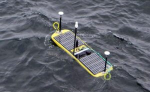
Autonomous wave gliders allow measurements to the nearest centimeter
In the project, a key role was played by autonomous vessels that operate on the water surface. These so-called wave gliders, in the development of which Prof. James Foster from the Institute of Geodesy at the University of Stuttgart was also involved, are equipped with both GNSS and acoustic measuring devices. The modern technology allowed measurements of the movements in the subduction zones to the nearest centimeter and thus a precise picture of the complicated slip processes and faults. Particular attention was paid to the shallow portions of the slip zones, as these are critical to whether or not a tsunami will occur.
The measurements were taken at a water depth of 1,000 to 2,000 meters. “It would be even better if we could take measurements at a water depth of 3,000 to 4,000 meters, directly above the shallowest part of the fault system,” says Foster.
However, the geodetic systems currently used on the seafloor cannot be used at these depths. The tsunami researcher is all the more pleased that, thanks to funding by the German Research Foundation and in cooperation with the GEOMAR Helmholtz Center for Ocean Research in Kiel, he will soon be able to purchase a device whose sensors allow geodetic measurements at these depths. “With this system, we will be able to directly measure the movement of the seafloor in these deepest sections of tsunamigenic faults.”
Prof. James Foster, University of Stuttgart, Institute of Geodesy, phone: +49 711 685 83459, email james.foster@gis.uni-stuttgart.de


Earthquakes in the American state of Utah, the Soultz-sous-Forêts region of France or in the Dutch province of Groningen should not be able to occur even if the subsurface has been exploited for decades. This is because the shallow subsurface behaves in such a way that faults there become stronger as soon as they start moving. At least that is what geology textbooks teach us. And so, in theory, it should not be possible for earthquakes to occur. So why…

Just in time for Halloween, researchers from the Royal Ontario Museum (ROM), the Field Museum in Chicago, and Lawrence University in Wisconsin have announced the discovery of six new species of bats. These newly identified species, all found in the Philippines, belong to the group known as tube-nosed bats—a fascinating and diverse branch of the mammal family tree. Expanding the Tree of Life Formally recognized as new species through morphological and genetic analysis, this discovery expands the already impressive global…
In a recent study published today in the European Geosciences Union (EGU) journal Biogeosciences, scientists have confirmed that mercury pollution from artisanal and small-scale gold mining (ASGM) is contaminating food crops not through the soil, as previously believed, but directly from the air. Driven by the surging price of gold, which has increased by more than tenfold since 2000, the rapid expansion of unregulated mining in these regions raises urgent questions about food security, human health, and environmental justice The…
A new study from Iceland’s Surtsey island shows that birds carried most of the plants that colonised the island, challenging long-held beliefs that seed or fruit shape determines how plants spread — offering fresh insight into life’s adaptation to c When the volcanic island of Surtsey rose from the North Atlantic Ocean in 1963, it offered scientists a once-in-a-lifetime opportunity to observe how life takes hold on a brand-new and barren land. For decades, ecologists believed that plants’ ability to…
