Feeding 9 Billion: Innovations in Agricultural Modeling
The first tropical depression formed around 11 a.m. EDT on May 15. NASA’s Aqua satellite flew over Tropical Depression 1-E (TD1E) at 0823 UTC (4:23 a.m. EDT) and the Atmospheric Infrared Sounder (AIRS) instrument captured an infrared image of the storm.
AIRS data showed bands of thunderstorms wrapping into the low-level center from the west, as well as a fragmented band of thunderstorms east of center. Cloud top temperatures of the thunderstorms were as cold as -63 Fahrenheit (-52 Celsius) indicating strong thunderstorms with heavy rainfall potential.
At 11 a.m. EDT on May 15, TD1E had maximum sustained winds near 35 mph (55 kph). It was located far from land, about 650 miles (1,045 km) south-southwest of Acapulco, Mexico, near 9.2 north latitude and 103.6 west longitude. TD1E was moving to the west at 12 mph (19 kph) and had a minimum central pressure near 1006 millibars. There are no coastal warnings or watches in effect.
The National Hurricane Center noted that TD1E will be moving through warm waters over the next couple of days, which will likely strengthen it into Tropical Storm Alvin.
Text credit: Rob Gutro
NASA’s Goddard Space Flight Center




Earthquakes in the American state of Utah, the Soultz-sous-Forêts region of France or in the Dutch province of Groningen should not be able to occur even if the subsurface has been exploited for decades. This is because the shallow subsurface behaves in such a way that faults there become stronger as soon as they start moving. At least that is what geology textbooks teach us. And so, in theory, it should not be possible for earthquakes to occur. So why…
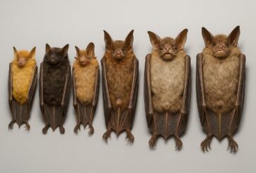
Just in time for Halloween, researchers from the Royal Ontario Museum (ROM), the Field Museum in Chicago, and Lawrence University in Wisconsin have announced the discovery of six new species of bats. These newly identified species, all found in the Philippines, belong to the group known as tube-nosed bats—a fascinating and diverse branch of the mammal family tree. Expanding the Tree of Life Formally recognized as new species through morphological and genetic analysis, this discovery expands the already impressive global…
In a recent study published today in the European Geosciences Union (EGU) journal Biogeosciences, scientists have confirmed that mercury pollution from artisanal and small-scale gold mining (ASGM) is contaminating food crops not through the soil, as previously believed, but directly from the air. Driven by the surging price of gold, which has increased by more than tenfold since 2000, the rapid expansion of unregulated mining in these regions raises urgent questions about food security, human health, and environmental justice The…
A new study from Iceland’s Surtsey island shows that birds carried most of the plants that colonised the island, challenging long-held beliefs that seed or fruit shape determines how plants spread — offering fresh insight into life’s adaptation to c When the volcanic island of Surtsey rose from the North Atlantic Ocean in 1963, it offered scientists a once-in-a-lifetime opportunity to observe how life takes hold on a brand-new and barren land. For decades, ecologists believed that plants’ ability to…
 Feedback