NASA satellites assist states in estimating abundance of key wildlife species
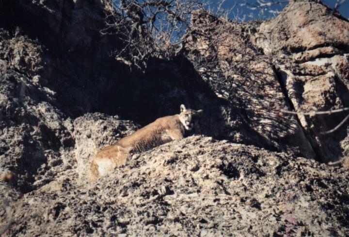
Mountain lions are the most common predator of mule deer in western North American ecosystems; their distribution, abundance, and population trends are closely tied to those of their prey (adult female in the Oquirrh Mountains, Utah) Credit: photo by D. Stoner
By combining NASA satellite imagery with wildlife surveys conducted by state natural resources agencies, a team of researchers at Utah State University and the University of Maryland, and the U.S. Geological Survey modeled the effects of plant productivity on populations of mule deer and mountain lions. Specifically, they mapped the abundance of both species over a climatically diverse region spanning multiple western states.
These models provide new insights into how differences in climate are transmitted through the food chain, from plants to herbivores and then to predators. Prey and predator abundance both increased with plant productivity, which is governed by precipitation and temperature. Conversely, animals responded to decreases in food availability by moving and foraging over larger areas, which could lead to increased conflict with humans.
David Stoner, lead author of the study, “Climatically driven changes in primary production propagate through trophic levels” published today in the journal Global Change Biology, remarked that, “We expected to see that satellite measurements of plant productivity would explain the abundance of deer. However, we were surprised to see how closely the maps of productivity also predicted the distribution of the mountain lion, their major predator.”
The study also reveals a disruption in the way scientists study the biosphere. Joseph Sexton, Chief Scientist of terraPulse, Inc. and a coauthor on the study, described the changing technology, “Up until about a decade ago, we were limited to analyzing landscapes through highly simplified maps representing a single point in time.
This just doesn't work in regions experiencing rapid economic or environmental change–the map is irrelevant by the time it's finished.” Now, given developments in machine learning, “big data” computation, and the “cloud”, ecologists and other scientists are studying large, dynamic ecosystems in ever-increasing detail and resolution.
“We're now mining global archives of satellite imagery spanning nearly forty years, we're updating our maps in pace with ecosystem changes, and we're getting that information out to government agencies and private land managers working in the field”.
The authors predict that, by enabling land managers to monitor rangeland and agricultural productivity, forest loss and regrowth, urban growth, and the dynamics of wildlife habitat, this expanding stream of information will help humanity adapt to climate and other environmental changes.
Stoner noted, “State wildlife agencies are tasked with estimating animal abundance in remote and rugged habitats, which is difficult and expensive. Integration of satellite imagery can help establish baseline population estimates, monitor environmental conditions, and identify populations at risk to climate and land-use change.”
Media Contact
More Information:
http://dx.doi.org/10.1111/gcb.14364All latest news from the category: Life Sciences and Chemistry
Articles and reports from the Life Sciences and chemistry area deal with applied and basic research into modern biology, chemistry and human medicine.
Valuable information can be found on a range of life sciences fields including bacteriology, biochemistry, bionics, bioinformatics, biophysics, biotechnology, genetics, geobotany, human biology, marine biology, microbiology, molecular biology, cellular biology, zoology, bioinorganic chemistry, microchemistry and environmental chemistry.


Newest articles
A new look at the consequences of light pollution
GAME 2024 begins its experiments in eight countries. Can artificial light at night harm marine algae and impair their important functions for coastal ecosystems? This year’s project of the training…

Silicon Carbide Innovation Alliance to drive industrial-scale semiconductor work
Known for its ability to withstand extreme environments and high voltages, silicon carbide (SiC) is a semiconducting material made up of silicon and carbon atoms arranged into crystals that is…

New SPECT/CT technique shows impressive biomarker identification
…offers increased access for prostate cancer patients. A novel SPECT/CT acquisition method can accurately detect radiopharmaceutical biodistribution in a convenient manner for prostate cancer patients, opening the door for more…

