Salt flat indicates some of the last vestiges of Martian surface water
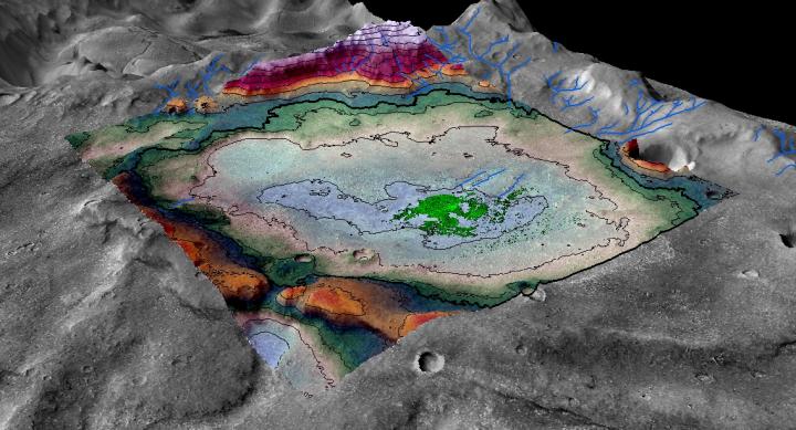
This is a perspective rendering of the Martian chloride deposit. Credit: LASP / Brian Hynek
The study, published Thursday in the journal Geology, examined an 18-square-mile chloride salt deposit (roughly the size of the city of Boulder) in the planet's Meridiani region near the Mars Opportunity rover's landing site. As seen on Earth in locations such as Utah's Bonneville Salt Flats, large-scale salt deposits are considered to be evidence of evaporated bodies of water.
Digital terrain mapping and mineralogical analysis of the features surrounding the deposit indicate that this one-time lakebed is no older than 3.6 billion years old, well after the time period when Mars is thought to have been warm enough to sustain large amounts of surface water planet-wide. Planetary scientists believe that the solar system formed approximately 4.6 billion years ago.
“This was a long-lived lake, and we were able to put a very good time boundary on its maximum age,” said Brian Hynek, a research associate at the Laboratory for Atmospheric and Space Physics (LASP) at CU-Boulder and lead author of the study. “We can be pretty certain that this is one of the last instances of a sizeable lake on Mars.”
Based on the extent and thickness of the salt, the researchers estimate that the lake was only about 8 percent as salty as the Earth's oceans and therefore may have been hospitable to microbial life.
“By salinity alone, it certainly seems as though this lake would have been habitable throughout much of its existence,” said Hynek, who is also an associate professor in the Department of Geological Sciences at CU-Boulder and director of the CU Center for Astrobiology. He noted, however, that other factors such as acidity levels were not included in the scope of the study.
###
Mikki Osterloo and Kathryn Kierein-Young, both research associates at the Laboratory for Atmospheric and Space Physics (LASP) at CU-Boulder, co-authored the study.
The University of Alaska Geophysical Institute's Remote Sensing Laboratory and the University of Arizona's High Resolution Imaging Science Experiment (HiRISE) team provided assistance with digital terrain mapping and data processing. The NASA-Mars Data Analysis Program provided funding for the research.
Media Contact
All latest news from the category: Physics and Astronomy
This area deals with the fundamental laws and building blocks of nature and how they interact, the properties and the behavior of matter, and research into space and time and their structures.
innovations-report provides in-depth reports and articles on subjects such as astrophysics, laser technologies, nuclear, quantum, particle and solid-state physics, nanotechnologies, planetary research and findings (Mars, Venus) and developments related to the Hubble Telescope.


Newest articles

Properties of new materials for microchips
… can now be measured well. Reseachers of Delft University of Technology demonstrated measuring performance properties of ultrathin silicon membranes. Making ever smaller and more powerful chips requires new ultrathin…

Floating solar’s potential
… to support sustainable development by addressing climate, water, and energy goals holistically. A new study published this week in Nature Energy raises the potential for floating solar photovoltaics (FPV)…

Skyrmions move at record speeds
… a step towards the computing of the future. An international research team led by scientists from the CNRS1 has discovered that the magnetic nanobubbles2 known as skyrmions can be…

