UT professor develops algorithm to improve online mapping of disaster areas
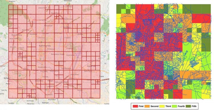
Yingjie Hu, UT assistant professor of geography, has developed an algorithm to improve online mapping of disaster areas. The image shows grid cells for disaster mapping (left) and cells prioritized using color codes (right). Credit: Yingjie Hu
This situation has been changed in recent years. Thanks to humanitarian organizations, such as the Humanitarian OpenStreetMap Team, web-based mapping platforms have been developed that enable volunteers to participate in remote disaster response.
Hu, now an assistant professor of geography at the University of Tennessee, Knoxville, and his colleagues have found a way to make the process more effective by developing an algorithm that indicates which areas need detailed mapping first. With better maps of the disaster zone, response teams can respond more efficiently to the most urgent needs.
Their paper was recently published in the journal Geographical Analysis.
In a typical web-based mapping project, volunteers review the most current remote sensing images, fill in the geographic data gaps and update the maps by, for example, indicating which roads are blocked after the disaster. Since there can be hundreds of volunteers working together, humanitarian organizations often divide the disaster-affected area into a number of grid cells. A volunteer can then choose one cell to start the mapping task.
Without any guidance on the mapping priorities, volunteers may map the grid cells in a random order.
Hu and his colleagues–Krzysztof Janowicz and Helen Couclelis, both of the University of California, Santa Barbara–developed an algorithm for prioritizing the mapping tasks. Their method takes into account the area's population, disaster severity and the road network and simulates potential rescue routes. The priorities of the grid cells are then ranked based on how the information within each cell can potentially assist the route-planning decisions of response teams. The result of the algorithm can help inform online volunteers about the priorities of the grid cells through color codes.
“Different grid cells contain different geographic content,” Hu said. “If online volunteers can first map the grid cells that are more urgent, response teams may be able to use the information at an earlier stage.”
He added that web mapping platforms are very valuable because they allow people to participate in disaster response even if they are far away from the disaster-affected area.
“Online volunteers provide up-to-date geographic information that can help disaster response teams on the ground to make more informed decisions,” he said.
Right now, Hu's algorithm only focuses on road networks.
“Within one grid, there can be other types of geographic information like hospital capacity or shelters,” Hu said. “Eventually, we could also quantify the value of these other types of geographic information and aggregate them to provide a more comprehensive rank of the grids.”
As a next step, Hu hopes to partner with humanitarian organizations to further test the algorithm in a real disaster.
Media Contact
All latest news from the category: Information Technology
Here you can find a summary of innovations in the fields of information and data processing and up-to-date developments on IT equipment and hardware.
This area covers topics such as IT services, IT architectures, IT management and telecommunications.


Newest articles

Superradiant atoms could push the boundaries of how precisely time can be measured
Superradiant atoms can help us measure time more precisely than ever. In a new study, researchers from the University of Copenhagen present a new method for measuring the time interval,…

Ion thermoelectric conversion devices for near room temperature
The electrode sheet of the thermoelectric device consists of ionic hydrogel, which is sandwiched between the electrodes to form, and the Prussian blue on the electrode undergoes a redox reaction…

Zap Energy achieves 37-million-degree temperatures in a compact device
New publication reports record electron temperatures for a small-scale, sheared-flow-stabilized Z-pinch fusion device. In the nine decades since humans first produced fusion reactions, only a few fusion technologies have demonstrated…

