MIT researchers map city by cellphone
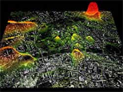
Street map of Graz, Austria, overlaid with an electronic visualization of cellphone activity.
Can you see me now?
Researchers at MIT may not be able to hear your cellphone call, but they have found a way to see it. They mapped a city in real time by tracking tens of thousands of people traveling about carrying cellphones.
Using anonymous cellphone data provided by the leading cellphone operator in Austria, A1/Mobilkom, the researchers developed the Mobile Landscapes project, creating electronic maps of cellphone use in the metropolitan area of Graz, Austria, the country’s second-largest city.
The researchers used three types of data — density of cellphone calls, origins and destinations of the calls, and position of users tracked at regular intervals — to create computer-generated images that can be overlayed with one another and with geographic and street maps of a city to show the peaks and valleys of the landscape as well as peaks in cellphone use.
“For the first time ever we are able to visualize the full dynamics of a city in real time,” said project leader Carlo Ratti, an architect/engineer and head of the SENSEable City Laboratory at the Massachusetts Institute of Technology. “This opens up new possibilities for urban studies and planning. The real-time city is now real: a system that is able to continuously sense its condition and can quickly react to its criticalities,” he added.
In recent years, techniques to locate and track mobile devices have become increasingly available; such techniques were crucial to law enforcement officials in their investigation of the Madrid and London terrorist bombings. MIT’s Mobile Landscapes project takes advantage of these techniques at an unprecedented scale by mapping an entire urban region continually at regular intervals.
The continuously changing electronic maps, which have a surprising aesthetic appeal, will be displayed at the M-City Exhibition at the Kunsthaus Graz from Oct. 1 to Jan. 8. Visitors to the show will be invited to participate in the electronic tracking by sending text messages to a server. “This participatory act aims to engage them in the issues of social networks and distributed interaction, but also on the possible drawbacks of limited privacy and geographical surveillance,” Ratti said.
The research could also have implications for use in large-scale emergencies and for transportation engineers seeking ways to better manage freeway traffic.
In addition to Ratti, designers on the project include MIT graduate students Daniel Berry, Sonya Huang, Xiongjiu Liao, Andrea Mattiello, Eugenio Morello and Andres Sevtsuk, and sophomore Daniel Gutierrez, senior David Lee and junior Jia Lou. The exhibition is funded by A1/Mobilkom, which provided data and technical assistance to MIT’s SENSEable City Laboratory.
Media Contact
More Information:
http://www.mit.eduAll latest news from the category: Information Technology
Here you can find a summary of innovations in the fields of information and data processing and up-to-date developments on IT equipment and hardware.
This area covers topics such as IT services, IT architectures, IT management and telecommunications.


Newest articles

Machine learning algorithm reveals long-theorized glass phase in crystal
Scientists have found evidence of an elusive, glassy phase of matter that emerges when a crystal’s perfect internal pattern is disrupted. X-ray technology and machine learning converge to shed light…

Mapping plant functional diversity from space
HKU ecologists revolutionize ecosystem monitoring with novel field-satellite integration. An international team of researchers, led by Professor Jin WU from the School of Biological Sciences at The University of Hong…

Inverters with constant full load capability
…enable an increase in the performance of electric drives. Overheating components significantly limit the performance of drivetrains in electric vehicles. Inverters in particular are subject to a high thermal load,…

