Enhanced zooming on maps
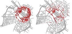
When a region of the road map is scaled up, distortions are created (red). Computer scientists of the University of Würzburg have developed a method (right) which significantly reduces the distortions when compared to the conventional fish-eye technique.<br>Picture: Jan-Henrik Haunert<br>
This is what computer scientists of the University of Würzburg are currently working on. One of their objectives is to develop maps the scale of which changes gradually rather than abruptly when zooming in and out. The first results of the scientists are published in a journal for visualization and computer graphics.
Imagine you plan a day trip to the city of Berlin by train. To prepare for the trip, you might take a look at the maps provided by Google or Bing. Where is the train station located in Berlin, which direction should I take for the city center and how will I get to the cathedral? As you are zooming in more deeply on the city map, discovering ever more details – at some point in time, the train station will no longer be displayed on the screen. Where was it again?
“If you use the zoom function of maps in the Internet, you will not get several views of one and the same map; instead, various different maps are presented so that there are sudden changes in the representation,” explains Professor Alexander Wolff of the Institute of Computer Science at the University of Würzburg. Therefore, users can easily get disoriented. Wolff and his colleague Jan-Henrik Haunert are going to remedy this problem – by means of maps with a variable scale. The project is funded by the German Research Foundation (DFG).
Enlarging individual regions on city maps
Variable scale – the Würzburg computer scientists have interactive maps in mind, on which individual regions can be viewed at a larger scale. Example: On an Internet map of Würzburg, a tourist would like to have a more detailed view of the streets leading to the Lion Bridge. He selects the respective point and gets an enlarged representation of the desired region. The residual part of the map shown on the screen continues to be displayed so that the total view of the city center is maintained.
Zoom method significantly improved
It has been possible for quite some time to implement this type of representation on the computer, using the so-called fish-eye technique. However, Jan-Henrik Haunert and the computer science student Leon Sering have recently developed a significantly improved method, presented in the December 2011 issue of the journal “IEEE Transactions on Visualization and Computer Graphics”.
The fish-eye technique has the following disadvantage: When scaling-up a certain region, the rest of the map is highly distorted. With the method of the Würzburg computer scientists, this distortion can be significantly reduced – by about 75 percent. By means of an even better variant of this method, the processing time of the computer for calculating the zoom operation can be reduced by half: In this case, only the area directly around the enlarged region is distorted. Here, the deformation is still 65 percent smaller when compared to the fish-eye technique.
Processing time must be shortened
Let’s consider processing time: At the moment, it takes several seconds, for instance, to calculate the city map of Würzburg anew with a desired scaled-up region. This may be acceptable to someone who just needs a one-time printout of a map. But it is far too slow for users browsing a city map in the Internet and it is obviously not fast enough for real-time applications in navigation systems. Furthermore, the technique is not suited to be used in smart phones either. “It is still based on extensive convex programming, for which smart phones do not have enough processing power,” says Professor Wolff.
Creating animated transitions between maps
So the method with the variable scale must be made faster. Over the coming three years, the computer scientists intend to achieve this target and some additional objectives in their DFG project. They also want to eliminate other effects that are likely to confuse users of interactive maps – such as the fact that the labels and the type of representation are subject to abrupt changes during zoom operations. For instance, users can get confused when the train station, which is initially represented as a point, suddenly changes into a large structure of railway tracks and buildings.
“As a solution to this problem, we are going to create animations that will allow smooth transitions between individual maps and different scales,” says Jan Haunert. “The generalization of the data is the fundamental problem here.” Generalization means in this case: For the animation, a detailed map together with its labels must be simplified step by step. When zooming, the user should finally get the impression that he is smoothly gliding along on one single map instead of switching from map to map and jumping from scale to scale. Then, it would be much more pleasant to plan a day trip to Berlin.
Project in the Internet Research Center
The DFG project of Alexander Wolff and Jan-Henrik Haunert is located at the Internet Research Center of the University of Würzburg. At this research center, computer scientists, psychologist and legal scholars focus on topics such as innovative web applications and a modern architecture of the World Wide Web.
“Drawing Road Networks with Focus Regions”, Jan-Henrik Haunert and Leon Sering, IEEE Transactions on Visualization and Computer Graphics, Vol. 17, Issue 12, 2555-2562, December 2011, DOI 10.1109/TVCG.2011.191
Read the publication: http://www1.informatik.uni-wuerzburg.de/pub/haunert/pdf/HaunertSering2011.pdf
Links
Further information on the research at the Department of Computer Science I at the University of Würzburg: http://www1.informatik.uni-wuerzburg.de/en/research/
To the Internet Research Center of the University of Würzburg: http://ircwiki.informatik.uni-wuerzburg.de/
Contact
Prof. Dr. Alexander Wolff, Department of Computer Science, University of Würzburg, T + 49 931 31-85055
Dr. Jan-Henrik Haunert, Department of Computer Science, University of Würzburg, T + 49 931 31-88668
Media Contact
More Information:
http://www.uni-wuerzburg.de/All latest news from the category: Information Technology
Here you can find a summary of innovations in the fields of information and data processing and up-to-date developments on IT equipment and hardware.
This area covers topics such as IT services, IT architectures, IT management and telecommunications.


Newest articles

“Nanostitches” enable lighter and tougher composite materials
In research that may lead to next-generation airplanes and spacecraft, MIT engineers used carbon nanotubes to prevent cracking in multilayered composites. To save on fuel and reduce aircraft emissions, engineers…

Trash to treasure
Researchers turn metal waste into catalyst for hydrogen. Scientists have found a way to transform metal waste into a highly efficient catalyst to make hydrogen from water, a discovery that…

Real-time detection of infectious disease viruses
… by searching for molecular fingerprinting. A research team consisting of Professor Kyoung-Duck Park and Taeyoung Moon and Huitae Joo, PhD candidates, from the Department of Physics at Pohang University…

