Rising Sea Levels Threaten Everglades Freshwater Plants
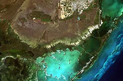
The study area, including the Southern Everglades, Florida City, Key Largo and other parts of Florida Bay and the upper Keys. Credit: CSTARS / Doug Fuller <br>
Just inland from the familiar salt-loving mangroves that line the Southern tip of the Florida Peninsula lie plant communities that depend on freshwater flowing south from Lake Okeechobee.
These communities provide critical habitats to many wildlife species, and as salt water intrudes, it could spell problems for freshwater plants and animals alike.
Satellite imagery over the southeastern Everglades confirms long-term trends of mangrove expansion and sawgrass habitat loss near the shore. The trend is related to salt water intrusion caused by sea-level rise and water management practices, according to a new study published in the scientific journal Wetlands.
“I was very surprised at how well the results matched our understanding of long-term trends and field data. Normally, we don’t see such clear patterns,” said Douglas Fuller, principal investigator of the study.
The findings show large patches of vegetation loss closer to the coast, approximately four kilometers from the shoreline, in and around a vegetative band of low productivity that has been shifting inland over the past 70 years. Growth trends were seen primarily in the interior, at about eight kilometers from the shore.
“Less salt-tolerant plants like the sawgrass, spike rush, and tropical hardwood hammocks are retreating. At the same time, salt-loving mangroves continue to extend inland,” said Fuller, professor of Geography and Regional studies in the College of Arts and Sciences at the University of Miami.
Changes in water management, such as the implementation of the Comprehensive Everglades Restoration Plan, may help offset the possible effects caused by future salt water intrusion. “However, restoration may not suffice if sea-level rise accelerates in the coming decades,” Fuller said.
Fuller and co-author Yu Wang, a former master’s student at UM, used satellite imagery from 2001 to 2010 over the southeastern Everglades, in an area called Taylor Slough, which is the second-largest flow-way for surface water in the Everglades, and stretches about 30 kilometers along the eastern boundary of Everglades National Park.
“These methods allowed us to perform a spatially comprehensive assessment of the trends, unlike research that has been limited to plot-level studies, in which careful measurements of plant cover and composition have been made over the past dozen years,” Fuller said. “These field studies, which provide confirmation of the satellite-based results, involved clipping and weighing plants found in sawgrass prairies and are part of a long-term effort to understand the dynamics of the ecosystems in the Everglades.”
The findings are shared in a paper titled “Recent Trends in Satellite Vegetation Index Observations Indicate Decreasing Vegetation Biomass in the Southeastern Saline Everglades Wetlands.”
In the future, the researchers would like to apply the methods used in their study to other coastal wetland areas that are threatened by sea-level rise.
Annette Gallagher can be reached at 305-284-1121.
Media Contact
All latest news from the category: Ecology, The Environment and Conservation
This complex theme deals primarily with interactions between organisms and the environmental factors that impact them, but to a greater extent between individual inanimate environmental factors.
innovations-report offers informative reports and articles on topics such as climate protection, landscape conservation, ecological systems, wildlife and nature parks and ecosystem efficiency and balance.


Newest articles
Wildfire danger to increase due to climate change
WSL Institute for Snow and Avalanche Research (SLF) researchers expect an elevated wildfire danger in the Alpine Foreland from 2040 onwards due to changing meteorological conditions. The danger currently remains…
Advanced Brain Science Without Coding Expertise
Researchers at Helmholtz Munich and the LMU University Hospital Munich introduce DELiVR, offering a new AI-based approach to the complex task of brain cell mapping. The deep learning tool democratizes…
Transparent emissive microdisplays
… for ultra-light and compact augmented reality systems. As part of the HOT project (High-performance transparent and flexible microelectronics for photonic and optical applications), scientists from the Fraunhofer Institute for…

