GMES comes under Earth and Space Week spotlight
Keeping watch on the world from orbit is helping to make it a safer place to live, heard European journalists visiting the Earth and Space Week in Brussels. Experts recounted how Europe’s Global Monitoring for Environment and Security initiative is already delivering operational information services and it is set for further expansion.
A day-long series of press briefings at the Earth and Space Expo focused on the joint initiative of the European Commission (EC) and ESA known as Global Monitoring for Environment and Security (GMES), intended to provide an independent European capability for global environmental monitoring by combining all available ground and space data sources.
The briefings came on the eve of the anticipated agreement to implement a Global Earth Observation System of Systems (GEOSS) at the Third Earth Observation Summit. With initial services already in operation, GMES will be the European contribution to GEOSS. Wednesday also marks the historic day that the Kyoto Protocol to combat global warming finally comes into effect, demonstrating that international cooperation for environmental protection is an idea whose time has come.
“Our environmental policies and legislation are based first and foremost on our knowledge of the state of the environment, what are the risks to it, what are the environmental trends,” said Timo Makela, Director in the EC Directorate-General for Environment. “What we know is that we do not know enough at the moment, and satellites and space can bring something additional to our existing monitoring.”
Makela explained that GMES services are already serving a wide range of users on an operational basis. Satellite images are being used to detect illegal dumping of oil waste from ships around European Union waters, so that the ships responsible can be identified. Meanwhile tiny millimetre-scale ground movements in Italian and Swiss territory are being detected using space-based radar techniques to create risk maps for landslides.
Humanitarian aid workers plan their activities with up-to-date satellite maps of their operational areas capable of highlighting flooded roads or earthquake-hit buildings – or even, as the briefing heard later, counting the number of individual tents in a crowded refugee camp to assess local needs.
GMES is less about suddenly constructing grand new monitoring systems than making better use of those that already exist. There are around 50 Earth Observation satellites currently in orbit around our planet, along with numerous ground-based observation systems – think of weather stations, tidal gauges or sea buoys – which gather a rich bounty of information on the ocean, atmosphere and land surfaces.
Blending all these Earth and space-based data together – along with numerical models to enable forecasting – can provide a richer and more accurate picture of our planet, providing information services robust enough to be used operationally, and in support of European decision makers.
Earth Observation in action
For examples of how Earth Observation is currently used in a practical way, Jacqueline McGlade, Executive Director of the European Environment Agency, explained how views from space enable monitoring of changes in European land cover.
“We can see that the landscape of Europe has a high ecological potential,” McGlade said. “There remains a lot of green landscape, but corridors between them are shrinking – impacting biodiversity – and a large area the size of a major city has been covered up by urban sprawl in a decade, so that if this rate stayed unchanged for forty years there would be little European open space left.” “These are the sort of changes that are almost imperceptible if you live down on the ground, but we can detect these shifts from orbit.”
Jean François-Minster, President and Director General of the French oceanographic body IFREMER turned to the ocean, revealing how satellite readings of sea surface temperature and height are blended with inputs from buoys and floats and a mathematical model of the ocean to create robust forecasting system known as Mercator.
With memories of the tragic Indian Ocean tsunami still fresh, disaster mitigation and response loomed large in discussions. Udo Gärtner, President of the German Meteorological Services Deutscher Wetterdienst pointed out that weather retains the power to do great harm to life and property – European floods in May 2002 did €20 billion worth of damage, while the 2003 heat wave killed an estimated 20 000 – but accurate forecasting can minimise disaster provided information gets out to those who need it in time.
Maryam Golnaragi, Chief of the Natural Disaster Prevention and Mitigation Programme of the World Meteorological Organisation (WMO) stated that 90% of global disasters between 1993 and 2002 were weather, climate or water related. Developing countries are typically hit the hardest. The WMO is researching means of reducing their exposure to such hazards by extending prediction lead time and quality.
Satellites have clearly proved their worth in the field of disaster response: the International Charter on Space and Major Disasters makes satellite data available to civil protection authorities responding to emergency situations. First signed in 2000, it is activated on average once every two weeks, with recent activations including the Tsunami aftermath.
Delilah Al Khudhairy, Head of the Institute for the Protection and Security of the EC’s Joint Research Centre (JRC) in Italy used the tsunami disaster as a case study of what Earth Observation could do across a variety of timescales, from hours to weeks.
When initial news of the disaster came through in late December, the JRC began by combining publicly available regional elevation models, sourced from Space Shuttle radar data, with US satellite-based maps of global population density in order to estimate the area affected and the potential casualties.
“In the next few days it became possible to acquire coarse and medium resolution imagery from ESA and the US” Al Khudhairy stated. “This could be used in turn to plan optimal acquisitions of very high resolution imagery which is most useful for the early response of relief organisations, and now for the ongoing process of sustainable reconstruction.”
She added that GMES service consortium Respond is supplying value-added services and maps based on satellite data to relief organisations in the field.
Space Sentinels for GMES
With ESA’s starting portfolio of 12 GMES services up and running – known as the GMES Services Element (GSE) – the next step in the joint initiative is to further grow existing services into self-sustainability while gathering user requirements for further ones. Along with this comes evolving and integrating the GMES ground segment and – with uncertainty over long-term data continuity a barrier to user acceptance – developing a series of dedicated spacecraft known as Sentinels.
Five Sentinels are currently planned: the first one radar-based, the second hyperspectral, the third dedicated to ocean monitoring and the final two for atmospheric monitoring from geostationary and low Earth orbit respectively. These missions will be classed as ‘operational’ as opposed to scientific, comparable in status to weather satellites such as Europe’s Meteosat series.
During a panel on GMES and business, Paul Kamon, Chairman of the European Association of Remote Sensing Companies (EARSC) made the point that ensuring data continuity was vital for maintaining the independence and competitive status of European Earth Observation.
The panel also covered the fact that companies have many potential roles under the GMES umbrella: providers of infrastructure, acquiring data, carrying out value-adding processing and interpretation or as users of GMES services. Pascale Sourisse, Chief Executive Officer of Alcatel Space and Jean Dauphin, business development director of EADS-Astrium both stressed their companies’ willingness to play an active role in GMES across its entire value chain.
Nigel Press, Chief Executive Officer of Nigel Press Associates stressed the importance of small to medium enterprises (SMEs) in making GMES work. He explained that the current non-military Earth Observation sector was dominated by SMEs that had developed niche services for customers willing to pay – Dutch firm ARGOSS uses satellite data for tide and sea state forecasting to sailors and offshore industry, for instance, while his own firm provides radar-based natural oil seep detection for oil prospecting firms.
Projecting the GEOSS future
A working lunch saw the spotlight shift from GMES to GEOSS. It was hosted by co-chairs of the Group on Earth Observation (GEO) charged with creating the ten-year plan to implement GEOSS, due to be accepted by the Third Earth Observation Summit on Wednesday. The theme of the lunch was ‘Imagine if…’ we lived in a world where GEOSS was already a reality.
National Oceanic and Atmospheric Administration (NOAA) Administrator, Vice Admiral Conrad C. Lautenbacher rose to the challenge ably, comparing the likely impact of GEOSS to turning the Hubble Space Telescope back from imaging the furthest corners of the universe to look back at the Earth and cover it completely.
“We would be able to mitigate all sorts of catastrophes with a comprehensive Earth Observation system,” Lautenbacher said. “Undergoing a drought we may be able to forecast whether it was going to last one year or five years, which would make a big difference.”
Fellow GEO co-chair Rob Adam, Director-General of the South African Department of Science and Technology, added that developing nations stood to benefit from GEOSS in a number of ways. Its existence would first highlight identify and then progressively shrink severe data gaps associated with these countries.
Media Contact
All latest news from the category: Ecology, The Environment and Conservation
This complex theme deals primarily with interactions between organisms and the environmental factors that impact them, but to a greater extent between individual inanimate environmental factors.
innovations-report offers informative reports and articles on topics such as climate protection, landscape conservation, ecological systems, wildlife and nature parks and ecosystem efficiency and balance.


Newest articles

How 3D printers can give robots a soft touch
Soft skin coverings and touch sensors have emerged as a promising feature for robots that are both safer and more intuitive for human interaction, but they are expensive and difficult…
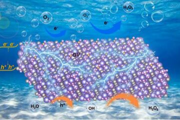
Oxygen vacancies mediated ultrathin Bi4O5Br2 nanosheets
… as efficient piezocatalyst for synthesis of H2O2 from pure water. As an important chemical raw material, hydrogen peroxide (H2O2) is widely applied in various aspects of industry and life….
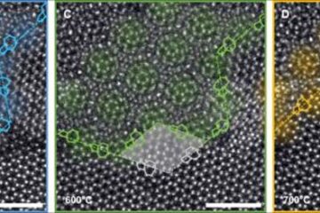
Atom-by-atom: Imaging structural transformations in 2D materials
Silicon-based electronics are approaching their physical limitations and new materials are needed to keep up with current technological demands. Two-dimensional (2D) materials have a rich array of properties, including superconductivity…

