Satellite Data to Track Wildlife: Elephants in Space
Threatened by habitat loss, poaching, pollution and other factors, wildlife species across the globe are declining in number at an alarming rate. Scientists from the Bronx Zoo-based Wildlife Conservation Society (WCS) in New York City have been monitoring endangered wildlife populations for more than 100 years. For decades, traditional capture and tag methods have been a primary tool, but they are not the most efficient when dealing with large animals and animals in remote locations. The WCS’s recent use of satellite technology, sponsored by NASA, may revolutionize the way endangered wildlife in remote areas of the world are counted and monitored.
Using cameras fixed to an orbiting satellite 450 kilometers (280 miles) overhead, WCS scientists say that they will be able to take high resolution photographs of specific areas to determine the wildlife composition within that area. They will then compare images from different dates to see changes, either population growth or decline, over time. The satellite, called Quickbird, is owned by DigitalGlobe, a private company.
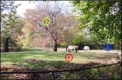
To test their proposed use of satellite images, WCS scientists recently counted their own animal populations. High-tech maps produced by Quickbird, which orbited the Bronx Zoo in November 2004, have revealed incredibly clear images of everything from giraffes to Thomson’s gazelles. According to members of the team, the detail of the images taken from so far away has been particularly impressive. “We’re counting individual gazelles in the zoo’s African Plains exhibit from a satellite 280 miles up,” said Dr. Scott Bergen. “That’s like standing on top of the Empire State Building and spotting a deer in Maine.”
Preliminary results of the study have left scientists hopeful that the technology can be used to monitor endangered wildlife populations that live in hard-to-reach locations, saving them time and money while saving the animals the hardship of being captured and tagged.
Dr. Eric Sanderson, a WCS landscape ecologist who is managing the study said, “Imagine being able to monitor a herd of elephants in the Serengeti, or a flock of endangered flamingos in Bolivia, from a lab in New York. This technology may allow us to do just that.”
WCS plans to use the Quickbird satellite technology in the near future to count wildlife in exotic locations, including elephants and giraffes in Tanzania, flamingos in South America, and elk, bison and antelope in Wyoming. WCS scientists will analyze those images as well to compare counts of wildlife living in other wild places. “This experiment is another powerful example of how WCS can use its world-class zoos in New York City to help save wildlife living half a world away,” said Richard L. Lattis, General Director of WCS’ zoos and aquarium.
DigitalGlobe developed Quickbird to offer highly accurate, commercial high-resolution imagery of Earth. According to the company’s Web site, “QuickBird’s global collection of panchromatic and multispectral imagery is designed to support applications ranging from map publishing to land and asset management to insurance risk assessment.” The satellite is able to geolocate features to within 23 meters (75.5 feet) and create maps in remote areas without the use of ground control points.
WCS, the Bronx Zoo’s parent organization, currently operates more that 350 field conservation projects in 54 countries around the world. WCS’s mission is to combine the resources of wildlife parks in New York with field projects around the globe to help sustain our planet’s biological diversity. The project was funded in part by a grant from NASA in support of the Agency’s mission to improve life here, extend life to there, and to find life beyond.
Media Contact
All latest news from the category: Ecology, The Environment and Conservation
This complex theme deals primarily with interactions between organisms and the environmental factors that impact them, but to a greater extent between individual inanimate environmental factors.
innovations-report offers informative reports and articles on topics such as climate protection, landscape conservation, ecological systems, wildlife and nature parks and ecosystem efficiency and balance.


Newest articles

Superradiant atoms could push the boundaries of how precisely time can be measured
Superradiant atoms can help us measure time more precisely than ever. In a new study, researchers from the University of Copenhagen present a new method for measuring the time interval,…

Ion thermoelectric conversion devices for near room temperature
The electrode sheet of the thermoelectric device consists of ionic hydrogel, which is sandwiched between the electrodes to form, and the Prussian blue on the electrode undergoes a redox reaction…

Zap Energy achieves 37-million-degree temperatures in a compact device
New publication reports record electron temperatures for a small-scale, sheared-flow-stabilized Z-pinch fusion device. In the nine decades since humans first produced fusion reactions, only a few fusion technologies have demonstrated…

