USGS projects large loss of Alaska permafrost by 2100
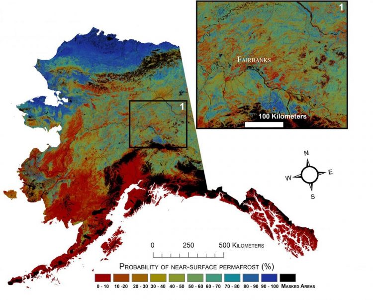
See USGS press release (link) or research article for future scenarios. Credit: USGS
Northern latitude tundra and boreal forests are experiencing an accelerated warming trend that is greater than in other parts of the world. This warming trend degrades permafrost, defined as ground that stays below freezing for at least two consecutive years.
Some of the adverse impacts of melting permafrost are changing pathways of ground and surface water, interruptions of regional transportation, and the release to the atmosphere of previously stored carbon.
“A warming climate is affecting the Arctic in the most complex ways,” said Virginia Burkett, USGS Associate Director for Climate and Land Use Change.
“Understanding the current distribution of permafrost and estimating where it is likely to disappear are key factors in predicting the future responses of northern ecosystems to climate change.”
In addition to developing maps of near-surface permafrost distributions, the researchers developed maps of maximum thaw depth, or active-layer depth, and provided uncertainty estimates. Future permafrost distribution probabilities, based on future climate scenarios produced by the Intergovernmental Panel on Climate Change (IPCC), were also estimated by the USGS scientists.
Widely used IPCC climate scenarios anticipate varied levels of climate mitigation action by the global community.
These future projections of permafrost distribution, however, did not include other possible future disturbances in the future, such as wildland fires. In general, the results support concerns about permafrost carbon becoming available to decomposition and greenhouse gas emission.
The research has been published in Remote Sensing of Environment. The current near-surface permafrost map is available via ScienceBase.
Media Contact
All latest news from the category: Earth Sciences
Earth Sciences (also referred to as Geosciences), which deals with basic issues surrounding our planet, plays a vital role in the area of energy and raw materials supply.
Earth Sciences comprises subjects such as geology, geography, geological informatics, paleontology, mineralogy, petrography, crystallography, geophysics, geodesy, glaciology, cartography, photogrammetry, meteorology and seismology, early-warning systems, earthquake research and polar research.


Newest articles

Security vulnerability in browser interface
… allows computer access via graphics card. Researchers at Graz University of Technology were successful with three different side-channel attacks on graphics cards via the WebGPU browser interface. The attacks…

A closer look at mechanochemistry
Ferdi Schüth and his team at the Max Planck Institut für Kohlenforschung in Mülheim/Germany have been studying the phenomena of mechanochemistry for several years. But what actually happens at the…

Severe Vulnerabilities Discovered in Software to Protect Internet Routing
A research team from the National Research Center for Applied Cybersecurity ATHENE led by Prof. Dr. Haya Schulmann has uncovered 18 vulnerabilities in crucial software components of Resource Public Key…

