Update on Funny River Fire, southern Alaska
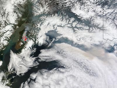
NASA's Terra satellite passed over the central Alaska and the Moderate Resolution Imaging Spectroradiometer (MODIS) instrument that flies aboard captured an image of smoke and hot spots from the Funny River Fire in southern Alaska on May 26 at 21:45 UTC (5:45 p.m. EDT). The heat from the fire appears red in the imagery and the smoke appears light brown. Credit: NASA image courtesy Jeff Schmaltz, NASA Goddard MODIS Rapid Response Team, Caption by NASA Goddard, Rob Gutro
On May 26 at 9:30 a.m. local time, the Alaska Interagency Incident Management Type 2 Team reported on the status of the fire through the multi-agency Incident Information System known as Inciweb.
At that time the fire was reported as 30 percent contained and had affected 158,585 acres. The report noted that the Funny River Fire crossed the Kenai River Sunday afternoon (May 26) near Torpedo Lake just east of the Kenai Keys.
The fire is wind driven fire and the Alaska Interagency Incident Management Type 2 Team noted that it was continuing to spread northeast toward the Skilak Lake Road.
The Lower Skilak Lake Campground was evacuated and is closed until further notice. The Kenai Keys area is under an evacuation advisory.
The Evacuation Advisory for the Kasilof area (Pollard Loop and Cardwell subdivisions) was lifted, effective Monday, May 26.
The evacuation order for the Funny River Road area between mile point 7 and the east end of the road remains in place.
The evacuation advisory for the Keys area on the north side of the Kenai River also remains in effect. For updates on the fire, visit Inciweb: http://inciweb.nwcg.gov/incident/3878/
NASA image courtesy Jeff Schmaltz, NASA Goddard MODIS Rapid Response Team, Caption by NASA Goddard, Rob Gutro
Media Contact
All latest news from the category: Earth Sciences
Earth Sciences (also referred to as Geosciences), which deals with basic issues surrounding our planet, plays a vital role in the area of energy and raw materials supply.
Earth Sciences comprises subjects such as geology, geography, geological informatics, paleontology, mineralogy, petrography, crystallography, geophysics, geodesy, glaciology, cartography, photogrammetry, meteorology and seismology, early-warning systems, earthquake research and polar research.


Newest articles

Silicon Carbide Innovation Alliance to drive industrial-scale semiconductor work
Known for its ability to withstand extreme environments and high voltages, silicon carbide (SiC) is a semiconducting material made up of silicon and carbon atoms arranged into crystals that is…

New SPECT/CT technique shows impressive biomarker identification
…offers increased access for prostate cancer patients. A novel SPECT/CT acquisition method can accurately detect radiopharmaceutical biodistribution in a convenient manner for prostate cancer patients, opening the door for more…

How 3D printers can give robots a soft touch
Soft skin coverings and touch sensors have emerged as a promising feature for robots that are both safer and more intuitive for human interaction, but they are expensive and difficult…

