Typhoon Sanvu had a bad weekend
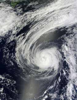
This visible image of Typhoon Sanvu was taken from the MODIS instrument onboard NASA's Terra satellite on May 26, 2012, at 0130 UTC (May 25 at 9:30 p.m. U.S./EDT). By this time Sanvu had weakened and its eye was no longer visible. Credit: Credit: NASA Goddard MODIS Rapid Response Team<br>
NASA's Aqua satellite captured an infrared image of Typhoon Sanvu on May 25 at 1559 UTC (11:59 a.m. EDT) when Sanvu was around its peak. The image clearly showed a visible eye surrounded by strong thunderstorms with high, cold cloud top temperatures.
Those cloud-top temperatures were colder than -63 Fahrenheit (-52 Celsius) indicating they were high in the troposphere. Those strong storms were generating rainfall rates of more than 1 inch (25.4 mm) per hour.
A visible image of Typhoon Sanvu was taken from the Moderate Resolution Imaging Spectroradiometer (MODIS) instrument onboard NASA's Terra satellite on May 26, 2012 at 0130 UTC (May 25 at 9:30 p.m. U.S./EDT). By that time Sanvu had weakened as it moved into cooler sea surface temperatures and its eye was no longer visible.
Sanvu ran into much cooler ocean temperatures and wind shear that quickly weakened it over the May 27-28 weekend. On May 27, Tropical Storm Sanvu passed Chichi Jima and entered the open waters of the Pacific. At 5 a.m. EDT on May 27, Sanvu was about 245 miles east of Chichi Jima island, Japan and moving east-northeast at 15 knots (17.2 mph/27.8 kph).
Wind shear was pushing most of the rainfall to the northeast of the center and weakening the storm, as was seen in a satellite image from NASA's Tropical Rainfall Measuring Mission (TRMM) satellite. It was on May 27, that the final warning on Sanvu was issued the Joint Typhoon Warning Center.
Media Contact
More Information:
http://www.nasa.govAll latest news from the category: Earth Sciences
Earth Sciences (also referred to as Geosciences), which deals with basic issues surrounding our planet, plays a vital role in the area of energy and raw materials supply.
Earth Sciences comprises subjects such as geology, geography, geological informatics, paleontology, mineralogy, petrography, crystallography, geophysics, geodesy, glaciology, cartography, photogrammetry, meteorology and seismology, early-warning systems, earthquake research and polar research.


Newest articles

Superradiant atoms could push the boundaries of how precisely time can be measured
Superradiant atoms can help us measure time more precisely than ever. In a new study, researchers from the University of Copenhagen present a new method for measuring the time interval,…

Ion thermoelectric conversion devices for near room temperature
The electrode sheet of the thermoelectric device consists of ionic hydrogel, which is sandwiched between the electrodes to form, and the Prussian blue on the electrode undergoes a redox reaction…

Zap Energy achieves 37-million-degree temperatures in a compact device
New publication reports record electron temperatures for a small-scale, sheared-flow-stabilized Z-pinch fusion device. In the nine decades since humans first produced fusion reactions, only a few fusion technologies have demonstrated…

