Twenty-first depression forms in eastern Pacific Ocean
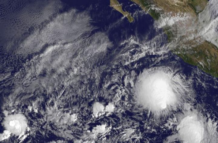
On Nov. 18 at 1500 UTC (10:00 a.m. EST), the NOAA's GOES-West satellite saw the Tropical Depression 21E form well southwest of the western Mexican coast. Credits: NASA/NOAA GOES Project
On Nov. 18 at 1500 UTC (10:00 a.m. EST), the NOAA's GOES-West satellite saw the Tropical Depression 21E form well southwest of the western Mexican coast. The storm appeared rounded in GOES imagery, but the storm was being affected by wind shear.
Forecaster Kimberlain at the National Hurricane Center said “These data and first-light visible satellite imagery also indicate that the center of the cyclone is near the southeastern edge of large mass of cold-topped convection, suggesting the presence of some southeasterly [vertical wind] shear.”
At 11 a.m. EST (1600 UTC), the center of Tropical Depression Twenty-One-E was located near latitude 13.0 north, longitude 107.2 west.
That puts the center about 455 miles (735 km) south-southwest of Manzanillo, Mexico. The estimated minimum central pressure is 1005 millibars.
The depression was moving toward the north near 2 mph (4 kph), and this general motion is expected to continue today.
A turn toward the north-northwest and then northwest is expected Thursday and Friday with an increase in forward speed. Maximum sustained winds are near 35 mph (55 km/h) with higher gusts.
Some strengthening is forecast during the next 48 hours, and the depression is expected to become a tropical storm tonight or Thursday, Nov. 19.
The National Hurricane Center forecast track turns the storm away from the coast, toward the west-northwest. For updated forecasts, visit: http://www.
Media Contact
All latest news from the category: Earth Sciences
Earth Sciences (also referred to as Geosciences), which deals with basic issues surrounding our planet, plays a vital role in the area of energy and raw materials supply.
Earth Sciences comprises subjects such as geology, geography, geological informatics, paleontology, mineralogy, petrography, crystallography, geophysics, geodesy, glaciology, cartography, photogrammetry, meteorology and seismology, early-warning systems, earthquake research and polar research.


Newest articles

Silicon Carbide Innovation Alliance to drive industrial-scale semiconductor work
Known for its ability to withstand extreme environments and high voltages, silicon carbide (SiC) is a semiconducting material made up of silicon and carbon atoms arranged into crystals that is…

New SPECT/CT technique shows impressive biomarker identification
…offers increased access for prostate cancer patients. A novel SPECT/CT acquisition method can accurately detect radiopharmaceutical biodistribution in a convenient manner for prostate cancer patients, opening the door for more…

How 3D printers can give robots a soft touch
Soft skin coverings and touch sensors have emerged as a promising feature for robots that are both safer and more intuitive for human interaction, but they are expensive and difficult…

