Tropical storm Carlos lingering off Mexico's southwestern coast
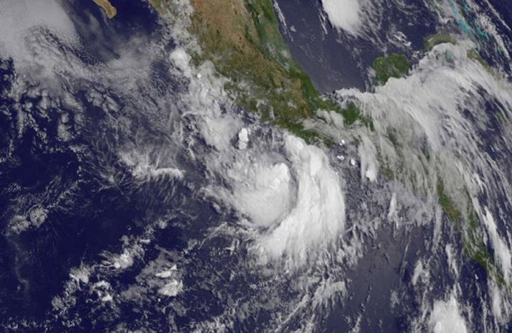
On June 12 at 15:00 UTC (11:00 a.m. EDT) NOAA's GOES-West satellite captured this visible image of Tropical Storm Carlos off the coast of southwestern Mexico. Courtesy of NASA/NOAA GOES Project
On June 12 at 15:00 UTC (11:00 a.m. EDT) NOAA's GOES-West satellite captured a visible image of tropical storm Carlos that showed bands of thunderstorms being pushed south and west of the center as a result of northeasterly wind shear. Clouds and showers in the northern quadrant of the storm were lacking. The image was created by the NASA/NOAA GOES Project at NASA's Goddard Space Flight Center, Greenbelt, Md.
At 11 a.m. EDT on June 12, the National Hurricane Center noted that a tropical storm watch is in effect from Acapulco to Zihuatanejo. A tropical storm watch means that tropical storm conditions are possible within the watch area, in this case within 36-48 hours.
Tropical storm conditions are possible within the watch area by Saturday night, June 13. Locally heavy rains could spread over portions of the southern coast of Mexico, primarily in the states of Oaxaca and Guerrero, during the next couple of days.
On June 12 at 11 a.m. EDT, tropical storm Carlos' maximum sustained winds were near 60 mph (95 kph). Carlos was centered near latitude 14.7 North, longitude 100.7 West. That puts the center of the storm about 160 miles (260 km) south-southwest of Acapulco, Mexico, and about 215 miles (345 km) south-southeast of Zihuatanejo, Mexico.
Carlos was stationary and is expected to move slowly northwest over the next couple of days. The estimated minimum central pressure is 997 millibars.
Ocean swells associated with Carlos are expected to increase near the coast of southern Mexico during the next few days. These swells could cause life-threatening surf and rip current conditions.
Forecaster Blake at the National Hurricane Center noted that 'Carlos continues to be affected by northeasterly shear with the center on the north side of the convection. While an overnight microwave pass showed some increase in organization of the inner core, radar from Acapulco and the latest satellite images suggest that the system has become less organized since then.'
According to the National Hurricane Center (NHC), during the next day or two, the northeasterly shear is forecast to persist, so only a gradual intensification of Carlos is anticipated. Carlos is expected to become a hurricane over the weekend. For updated forecasts, visit NHC: http://www.
Media Contact
All latest news from the category: Earth Sciences
Earth Sciences (also referred to as Geosciences), which deals with basic issues surrounding our planet, plays a vital role in the area of energy and raw materials supply.
Earth Sciences comprises subjects such as geology, geography, geological informatics, paleontology, mineralogy, petrography, crystallography, geophysics, geodesy, glaciology, cartography, photogrammetry, meteorology and seismology, early-warning systems, earthquake research and polar research.


Newest articles

Properties of new materials for microchips
… can now be measured well. Reseachers of Delft University of Technology demonstrated measuring performance properties of ultrathin silicon membranes. Making ever smaller and more powerful chips requires new ultrathin…

Floating solar’s potential
… to support sustainable development by addressing climate, water, and energy goals holistically. A new study published this week in Nature Energy raises the potential for floating solar photovoltaics (FPV)…

Skyrmions move at record speeds
… a step towards the computing of the future. An international research team led by scientists from the CNRS1 has discovered that the magnetic nanobubbles2 known as skyrmions can be…

