Tropical Depression Khanun blankets South Korea
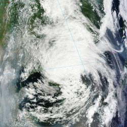
This true-color image of Tropical Depression Khanun over South Korea was captured by the MODIS instrument onboard NASA's Terra satellite at 0225 UTC, July 19, 2012.<br><br>Credit: Credit: NASA MODIS Rapid Response Team<br>
The Moderate Resolution Imaging Spectroradiometer (MODIS) instrument onboard NASA's Terra satellite captured a true-color image of Tropical Depression Khanun over South Korea on July 19, 2012 at 0225 UTC, or 11:25 a.m. local time, Seoul (10:25 p.m. EDT/U.S. on July 18).
The last advisory on Khanun from the Joint Typhoon Warning Center was issued at 0300 UTC (noon local time, Seoul, South Korea) on July 19, when the center was already over land. At that time, Khanun was centered about 15 miles south of Seoul, South Korea, near 37.2 North and 127.1 East. It was moving to the north-northeast at 16 knots (18.4 mph/29.6 kmh) and had maximum sustained winds near 30 knots (34.5 mph/55.5 kph), but was quickly weakening due to its interaction with land.
Khanun caused flooding and power outages, and affected major transportation systems, according to the Korea Herald. One fatality was reported in the North Gyeongsang Province when the wall of a home collapsed. Warnings were dropped in the early afternoon as Khanun continued to weaken and move inland.
Jeju Island, which felt the effects of Khanun first as it approached from the south and the South Jeolla Province both experienced heavy rainfall and power outages from the storm, according to the Korea Herald. The Korean Meteorological Administration reported that 2.1 inches (53.4 millimeters) or rain fell in Jeju, while as much as 3.8 (97 millimeters) fell on Suncheon, located in the South Jeolla Province.
The Korean Meteorological Administration noted that the center of Khanun's remnants had moved over the Sea of Japan by 11 a.m. EDT on July 19, 2012.
Media Contact
More Information:
http://www.nasa.govAll latest news from the category: Earth Sciences
Earth Sciences (also referred to as Geosciences), which deals with basic issues surrounding our planet, plays a vital role in the area of energy and raw materials supply.
Earth Sciences comprises subjects such as geology, geography, geological informatics, paleontology, mineralogy, petrography, crystallography, geophysics, geodesy, glaciology, cartography, photogrammetry, meteorology and seismology, early-warning systems, earthquake research and polar research.


Newest articles

High-energy-density aqueous battery based on halogen multi-electron transfer
Traditional non-aqueous lithium-ion batteries have a high energy density, but their safety is compromised due to the flammable organic electrolytes they utilize. Aqueous batteries use water as the solvent for…

First-ever combined heart pump and pig kidney transplant
…gives new hope to patient with terminal illness. Surgeons at NYU Langone Health performed the first-ever combined mechanical heart pump and gene-edited pig kidney transplant surgery in a 54-year-old woman…

Biophysics: Testing how well biomarkers work
LMU researchers have developed a method to determine how reliably target proteins can be labeled using super-resolution fluorescence microscopy. Modern microscopy techniques make it possible to examine the inner workings…

