Tropical Depression Keuna's rainfall weakens
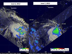
These two images of Kuena's rainfall from NASA's TRMM satellite show how the intensity waned between June 6 (left) and June 7 (right). The yellow, green and blue areas indicate light-to-moderate rainfall between 20 and 40 millimeters (.78 to 1.57 inches) per hour. The red area is considered heavy rainfall at 2 inches/50 mm per hour. There were no areas of heavy rain on June 7 as the system continued to weaken. Kuena's past and forecast track is shown overlaid in white on the left image. Credit: NASA/SSAI, Hal Pierce<br>
The Tropical Rainfall Measuring Mission satellite called TRMM measures how much rain can fall per hour in storms. Between June 6 and 7, TRMM noticed the rainfall rate within Tropical Depression Kuena had lessened.
A tropical storm called Kuena formed in the southwest Indian Ocean east of Madagascar on June 6, 2012. This is a little unusual because the tropical cyclone season in that area normally ends on May 15, although two tropical storms formed in the north Atlantic this year before that season even officially started, so tropical cyclones seem to be ignoring the calendar this year.
The TRMM satellite had an excellent view of Kuena when it flew directly above the newly formed storm on June 6, 2012 at 1607 UTC. A rainfall analysis was made at NASA's Goddard Space Flight Center in Greenbelt, Md. that used data from TRMM's Microwave Imager (TMI) and Precipitation Radar (PR) instruments. That analysis was overlaid on an enhanced infrared image from TRMM's Visible and InfraRed Scanner (VIRS) instrument and showed heavy convective storms were dropping intense rainfall of over 50mm/hr (~2 inches) within the storm. A 3-D analysis of Kuena's vertical structure showed that a few of these powerful storms within Kuena were pushing to heights above 15km (~9.3 miles).
The TRMM satellite had another fairly good look at Kuena on June 7, 2012 at 0158 UTC. Data from TRMM's TMI instrument shows that Kuena was producing moderate rainfall over a large area of the south Indian Ocean east of Madagascar. There were no areas of intense rainfall on June 7, as there were on June 6.
At 1500 UTC (10 a.m. EDT) on June 7, the Joint Typhoon Warning Center noted that the last position of the low's center was near 8.7 South latitude and 55.5 East longitude. It was moving in a northwest direction as it continued weakening until it dissipated under strong wind shear conditions.
Media Contact
More Information:
http://www.nasa.govAll latest news from the category: Earth Sciences
Earth Sciences (also referred to as Geosciences), which deals with basic issues surrounding our planet, plays a vital role in the area of energy and raw materials supply.
Earth Sciences comprises subjects such as geology, geography, geological informatics, paleontology, mineralogy, petrography, crystallography, geophysics, geodesy, glaciology, cartography, photogrammetry, meteorology and seismology, early-warning systems, earthquake research and polar research.


Newest articles

Combatting disruptive ‘noise’ in quantum communication
In a significant milestone for quantum communication technology, an experiment has demonstrated how networks can be leveraged to combat disruptive ‘noise’ in quantum communications. The international effort led by researchers…

Stretchable quantum dot display
Intrinsically stretchable quantum dot-based light-emitting diodes achieved record-breaking performance. A team of South Korean scientists led by Professor KIM Dae-Hyeong of the Center for Nanoparticle Research within the Institute for…

Internet can achieve quantum speed with light saved as sound
Researchers at the University of Copenhagen’s Niels Bohr Institute have developed a new way to create quantum memory: A small drum can store data sent with light in its sonic…

