Tropical Depression 11W moving past Yap and Guam
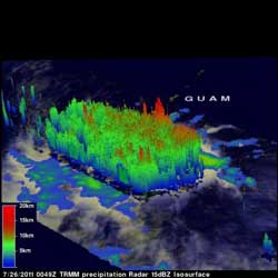
The Tropical Rainfall Measuring Mission (TRMM) satellite data was used to create a 3-D image of Tropical Depression 11W's rainfall and cloud heights as it passed overhead on July 26. TD11W had towering convective storms near their centers of circulation that extended to heights above 15km (~9.3 miles) with heavy rainfall, falling at 2 inches (50 mm) per hour. Credit: NASA/SSAI, Hal Pierce<br>
Yap and Guam are both experiencing the tail end of gusty winds and rains as Tropical Depression 11W moves between the two islands in the western North Pacific today.
At 0900 UTC (5 a.m. EDT) on July 27, Tropical Depression 11W's (TD11W) maximum sustained winds were still near 30 knots (34 mph). It was located about 290 nautical miles southwest of Andersen Air Force Base, Guam near 10.7 North and 140.5 East. It was moving to the northwest near 12 knots (14 mph).
When NASA's Aqua satellite passed over TD11W on July 26 at 16:05 UTC (12:05 p.m. EDT) the center of circulation appeared much more rounded than it had in the previous days, indicating that the storm was getting better organized. The Atmospheric Infrared Sounder (AIRS) instrument captured the infrared image that showed powerful, high thunderstorms with cold cloud tops surrounded the center of TD11W's circulation, although the center is partially exposed to outside winds. There were also a number of bands of thunderstorms around the center. TD11W is kicking up waves of 12 feet high, and generating rough surf at Yap and Guam.
TD11W is moving around the western edge of a low to mid-level ridge of high pressure, and will continue in a northwestward direction for the next day or two. After that, the ridge is expected to weaken and the storm track will head in a more northeasterly direction.
Media Contact
More Information:
http://www.nasa.govAll latest news from the category: Earth Sciences
Earth Sciences (also referred to as Geosciences), which deals with basic issues surrounding our planet, plays a vital role in the area of energy and raw materials supply.
Earth Sciences comprises subjects such as geology, geography, geological informatics, paleontology, mineralogy, petrography, crystallography, geophysics, geodesy, glaciology, cartography, photogrammetry, meteorology and seismology, early-warning systems, earthquake research and polar research.


Newest articles

Properties of new materials for microchips
… can now be measured well. Reseachers of Delft University of Technology demonstrated measuring performance properties of ultrathin silicon membranes. Making ever smaller and more powerful chips requires new ultrathin…

Floating solar’s potential
… to support sustainable development by addressing climate, water, and energy goals holistically. A new study published this week in Nature Energy raises the potential for floating solar photovoltaics (FPV)…

Skyrmions move at record speeds
… a step towards the computing of the future. An international research team led by scientists from the CNRS1 has discovered that the magnetic nanobubbles2 known as skyrmions can be…

