Team Develops New, Inexpensive Method for Understanding Earthquake Topography
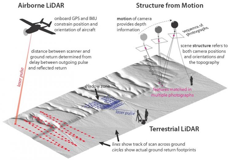
Figure 1 from K. Johnson et al.: Schematic illustration of three methods of producing high-resolution digital topography. Click on figure for larger image.
However, current methods of acquisition are costly and require trained personnel with high-tech, cumbersome equipment. In light of this, Kendra Johnson and colleagues have developed a new system that takes advantage of affordable, user-friendly equipment and software to produce topography data over small, sparsely vegetated sites at comparable (or better) resolution and accuracy to standard methods.
Their workflow is based on structure from motion (SfM), which uses overlapping photographs of a scene to produce a 3-D model that represents the shape and scale of the terrain. To acquire the photos, Johnson and colleagues attached a camera programmed to take time-lapse photos to a helium balloon or small, remote-controlled glider. They augmented the aerial data by recording a few GPS points of ground features that would be easily recognized in the photographs.
Using a software program called Agisoft Photoscan, they combined the photographs and GPS data to produce a robust topographic model.
Johnson and colleagues note that this SfM workflow can be used for many geologic applications. In this study for GEOSPHERE, Johnson and colleagues focused on its potential in studying active faults that pose an earthquake hazard.
They targeted two sites in southern California, each of which has existing topography data collected using well-established, laser-scanning methods.
The first site covers a short segment of the southern San Andreas fault that historically has not had a large earthquake; however, the ground surface reveals evidence of prehistoric ruptures that help estimate the size and frequency of earthquakes on this part of the fault. The team notes that this evidence is more easily quantified using high-resolution topography data than by geologists working in the field.
The second site covers part of the surface rupture formed during the 1992 Landers earthquake (near Palm Springs, California, USA). Johnson and colleagues chose this site to test the capability of their workflow as part of the scientific response that immediately follows an earthquake.
At each site, they compared their SfM data to the existing laser scanner data and found that the values closely matched. Johnson and colleagues conclude that their new SfM workflow produces topography data at sufficient quality for use in earthquake research.
Contact:
Kea Giles
Managing Editor,
GSA Communications
+1-303-357-1057
kgiles@geosociety.org
Media Contact
All latest news from the category: Earth Sciences
Earth Sciences (also referred to as Geosciences), which deals with basic issues surrounding our planet, plays a vital role in the area of energy and raw materials supply.
Earth Sciences comprises subjects such as geology, geography, geological informatics, paleontology, mineralogy, petrography, crystallography, geophysics, geodesy, glaciology, cartography, photogrammetry, meteorology and seismology, early-warning systems, earthquake research and polar research.


Newest articles

“Nanostitches” enable lighter and tougher composite materials
In research that may lead to next-generation airplanes and spacecraft, MIT engineers used carbon nanotubes to prevent cracking in multilayered composites. To save on fuel and reduce aircraft emissions, engineers…

Trash to treasure
Researchers turn metal waste into catalyst for hydrogen. Scientists have found a way to transform metal waste into a highly efficient catalyst to make hydrogen from water, a discovery that…

Real-time detection of infectious disease viruses
… by searching for molecular fingerprinting. A research team consisting of Professor Kyoung-Duck Park and Taeyoung Moon and Huitae Joo, PhD candidates, from the Department of Physics at Pohang University…

