Significant contribution of Greenland's peripheral glaciers to sea-level rise
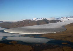
This is the Elephant Foot Glacier, NE-Greenland.<br>Credit: Dirk van AS (GEUS)<br>
The discovery, just published in Geophysical Research Letters, is important as it will help scientists improve the predictions of the future contribution of Greenland's ice to sea-level rise.
Using lasers which measure the height of the ice from space, and a recently completed inventory of Greenland's glaciers and ice caps, scientists from the European-funded ice2sea programme, were able to determine changes in the mass of those ice bodies, separate from the main ice sheet.
It also showed that the contribution to sea-level rise from the glaciers of Greenland separated from the ice sheet makes up around 10% of the estimated contribution of the entire world's glaciers and ice caps, and that contribution is higher than expected.
Lead author Dr. Tobias Bolch, from the University of Zurich, says, “The melting of ice on Greenland is known to be one of the major sources for global sea-level rise. Beside the large ice sheet, there are thousands of peripheral glaciers which are not connected to the ice sheet or can be separated from it due to the existence of ice divides. The area of those glaciers is about 50 times higher than the ice cover of the European Alps. Consequently, it is important to investigate not only the ice sheet but also these local glaciers.”
The paper, “Mass loss of Greenland's glaciers and ice caps 2003 – 2008 revealed from ICESat laser altimetry data”, showed glaciers with no or weak connection to the main ice sheet contributed to around 30 Gigatons (Gt) of water per year to sea level between 2003 and 2008.
When they added in glaciers which had some link to the ice sheet, but which were still distinct from it in the way they flowed, this figure increased to up to around 50 Gt per year. This yearly figure represents more than half the water contained in one of Europe's largest lakes, Lake Geneva.
The study gives more detail to the make-up and stability of Greenland's glaciers showing that mass loss is highest in the warmer south east of the land mass and lowest in the colder north.
It also shows that the loss of ice is about 2.5 times higher for those separate glaciers than for the ice sheet, leading to the 15-20% figure.
Dr. Bolch says, “The other 80-85% comes from the ice sheet. The new figure for the local glaciers is higher than expected. It matters because the ice loss with respect to the area is significantly higher than of the ice sheet. This means that the local glaciers react faster with respect to climate change. This information will help to improve the predictions of the future contribution of Greenland's ice to sea-level rise.”
A Gigaton (Gt) is the equivalent of 1 cubic kilometer (km3) of water. Lake Geneva contains about 90 km3 of water.
Literature:
T. Bolch, L. Sørensen, S. Simonssen, N. Mölg, H. Machguth, P. Rastner, F.,Paul. Mass loss of Greenland's glaciers and ice caps 2003-2008 revealed from ICESat data. Geophysical Research Letters, 40. March 15, 2013. doi: 10.1029/2012GL054710.
Contact:
Dr. Tobias Bolch
Department of Geography
University of Zurich
Phone +41 44 635 52 36
E-mail: tobias.bolch@geo.uzh.ch
For more information on ice2sea contact Paul B. Holland at the British Antarctic Survey Communications Office, Cambridge. Tel: +44 (0)1223 221226; Email: pbmho@bas.ac.uk.
Ice2sea brings together the EU's scientific and operational expertise from 24 leading institutions across Europe and beyond. Improved projections of the contribution of ice to sea-level rise produced by this major European-funded programme will inform the fifth IPCC report (due in 2013). In 2007, the fourth Intergovernmental Panel on Climate Change (IPCC) report highlighted ice-sheets as the most significant remaining uncertainty in projections of sea-level rise. Understanding about the crucial ice-sheet effects was “too limited to assess their likelihood or provide a best estimate of an upper bound for sea-level rise.”
Media Contact
More Information:
http://www.uzh.chAll latest news from the category: Earth Sciences
Earth Sciences (also referred to as Geosciences), which deals with basic issues surrounding our planet, plays a vital role in the area of energy and raw materials supply.
Earth Sciences comprises subjects such as geology, geography, geological informatics, paleontology, mineralogy, petrography, crystallography, geophysics, geodesy, glaciology, cartography, photogrammetry, meteorology and seismology, early-warning systems, earthquake research and polar research.


Newest articles

Security vulnerability in browser interface
… allows computer access via graphics card. Researchers at Graz University of Technology were successful with three different side-channel attacks on graphics cards via the WebGPU browser interface. The attacks…

A closer look at mechanochemistry
Ferdi Schüth and his team at the Max Planck Institut für Kohlenforschung in Mülheim/Germany have been studying the phenomena of mechanochemistry for several years. But what actually happens at the…

Severe Vulnerabilities Discovered in Software to Protect Internet Routing
A research team from the National Research Center for Applied Cybersecurity ATHENE led by Prof. Dr. Haya Schulmann has uncovered 18 vulnerabilities in crucial software components of Resource Public Key…

