Seismic gap outside of Istanbul
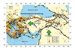
© GFZ Deutsches GeoForschungsZentrum <br>Erdbebengefährdung der Türkei, Epizentren und Lage der Haupt-Störungszonen<br>
Earthquake researchers have now identified a 30 kilometers long and ten kilometers deep area along the North Anatolian fault zone just south of Istanbul that could be the starting point for a strong earthquake.
The group of seismologists including Professor Marco Bohnhoff of the GFZ German Research Centre for Geosciences reported in the current online issue of the scientific journal /Nature/ (Nature Communications,DOI: 10.1038/ncomms2999) that this potential earthquake source is only 15 to 20 kilometers from the historic city center of Istanbul.
The Istanbul-Marmara region of northwestern Turkey with a population of more than 15 million faces a high probability of being exposed to an earthquake of magnitude 7 or more. To better understand the processes taking place before a strong earthquake at a critically pressurized fault zone, a seismic monitoring network was built on the Princes Islands in the Sea of Marmara off Istanbul under the auspices of the Potsdam based Helmholtz Centre GFZ together with the Kandilli Earthquake Observatory in Istanbul. The Princes Islands offer the only opportunity to monitor the seismic zone running below the seafloor from a distance of few kilometers.
The now available data allow the scientists around GFZ researcher Marco Bohnhoff to come to the conclusion that the area is locked in depth in front of the historic city of Istanbul: “/The block we identified reaches ten kilometers deep along the fault zone and has displayed no seismic activity since measurements began over four years ago. This could be an indication that the expected Marmara earthquake could originate there/”, says Bohnhoff.
This is also supported by the fact that the fracture zone of the last strong earthquake in the region, in 1999, ended precisely in this area – probably at the same structure, which has been impeding the progressive shift of the Anatolian plate in the south against the Eurasian plate in the north since 1766 and building up pressure. The results are also being compared with findings from other fault zones, such as the San Andreas Fault in California, to better understand the physical processes before an earthquake.
Currently, the GFZ is intensifying its activity to monitor the earthquake zone in front of Istanbul. Together with the Disaster and Emergency Management Presidency of Turkey AFAD, several 300 meter deep holes are currently being drilled around the eastern Marmara Sea, into which highly sensitive borehole seismometers will be placed. With this /Geophysical borehole Observatory at the North Anatolian Fault/ GONAF, measurement accuracy and detection threshold for microearthquakes are improved many times over. In addition, the new data also provide insights on the expected ground motion in the event of an earthquake in the region. Bohnhoff: “/Earthquake prediction is scientifically impossible. But studies such as this provide a way to better characterize earthquakes in advance in terms of location, magnitude and rupture progression, and therefore allow a better assessment of damage risk/.”
Marco Bohnhoff, Fatih Bulut, Georg Dresen, Peter E. Malin, Tuna Eken, Mustafa Aktar: “/An earthquake gap south of Istanbul/”, Nature,DOI:
10.1038/ncomms2999, 18.06.2013)
Images in printable resolution:
http://www.gfz-potsdam.de/portal/gfz/Public+Relations/M40-Bildarchiv/Bildergalerie+Erdbebengefahr+Tuerkei
Franz Ossing
Helmholtz Centre Potsdam
GFZ German Research Centre for Geosciences
Deutsches GeoForschungsZentrum
– Head, Public Relations –
Telegrafenberg
14473 Potsdam / Germany
e-mail: ossing@gfz-potsdam.de
Tel. ++49 (0)331-288 1040
Fax ++49 (0)331-288 1044
Media Contact
More Information:
http://www.gfz-potsdam.deAll latest news from the category: Earth Sciences
Earth Sciences (also referred to as Geosciences), which deals with basic issues surrounding our planet, plays a vital role in the area of energy and raw materials supply.
Earth Sciences comprises subjects such as geology, geography, geological informatics, paleontology, mineralogy, petrography, crystallography, geophysics, geodesy, glaciology, cartography, photogrammetry, meteorology and seismology, early-warning systems, earthquake research and polar research.


Newest articles

High-energy-density aqueous battery based on halogen multi-electron transfer
Traditional non-aqueous lithium-ion batteries have a high energy density, but their safety is compromised due to the flammable organic electrolytes they utilize. Aqueous batteries use water as the solvent for…

First-ever combined heart pump and pig kidney transplant
…gives new hope to patient with terminal illness. Surgeons at NYU Langone Health performed the first-ever combined mechanical heart pump and gene-edited pig kidney transplant surgery in a 54-year-old woman…

Biophysics: Testing how well biomarkers work
LMU researchers have developed a method to determine how reliably target proteins can be labeled using super-resolution fluorescence microscopy. Modern microscopy techniques make it possible to examine the inner workings…

