Satellites See Storm System that Created Moore, Okla., Tornado
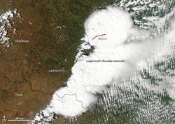
On May 20, 2013, a supercell thunderstorm in central Oklahoma spawned a destructive tornado that passed just south of Oklahoma City. The Moderate Resolution Imaging Spectroradiometer (MODIS) on NASA's Aqua satellite acquired this image of the storm at 2:40 p.m. local time (19:40 UTC). The red line depicts the tornado's track. The twister touched down west of Newcastle at 2:56 p.m. and moved northeast toward Moore, where it caused dozens of deaths and widespread destruction. The tornado had dissipated by 3:36 p.m., after traveling approximately 20 miles (32 kilometers).<br>Credit: NASA/Jeff Schmaltz, LANCE/EOSDIS MODIS Rapid Response Team at NASA Goddard; caption by Adam Voiland<br>
The tornado that struck Moore on the afternoon of Monday, May 20, was an F-4 tornado on the enhanced Fujita scale, according to the National Weather Service. F-4 tornadoes have sustained winds from 166 to 200 mph. This tornado was about twice as wide as the tornado that struck Moore on May 3, 1999. Moore is located 10 miles south of Oklahoma City.
Before, during and after the tornado, satellites provided imagery and data to forecasters. The first tornado warning was issued around 2:40 p.m. CDT (local time). By 3:01 p.m. CDT a tornado emergency was issued for Moore, and 35 minutes later at 3:36 p.m. CDT, the tornado spun down and dissipated.
NASA's Aqua satellite captured a visible-light image that provided a detailed look at the supercell thunderstorm. NOAA's GOES-13 satellite provided continuously updated satellite imagery depicting the storm's movement. After the tornado, the NASA-NOAA Suomi National Polar-orbiting Partnership satellite's lightning observations showed that the thunderstorm complex was still active after nightfall.
NOAA's GOES-13 satellite provided forecasters with images of the storm system every 15 minutes. One GOES-13 satellite image was captured at 19:55 UTC (2:55 p.m. CDT) as the tornado began its deadly swath. The tornado was generated near the bottom of a line of clouds resembling an exclamation mark. The GOES-13 satellite imagery from the entire day was assembled into an animation by the NASA GOES Project at NASA's Goddard Space Flight Center in Greenbelt, Md.
Four minutes after the tornado dissipated (19:40 UTC / 3:40 p.m. EDT), the Moderate Resolution Imaging Spectroradiometer (MODIS) instrument aboard NASA’s Aqua satellite captured a visible image of the supercell thunderstorm that spawned the Moore tornado. That image was created by the NASA Goddard MODIS Rapid Response Team and Adam Voiland, NASA Earth Observatory.
Later as the storm system continued through the region, another satellite captured an image of the storm at night that showed it was still powerful. The Visible Infrared Imaging Radiometer Suite aboard Suomi NPP observed lightning in a nighttime image on May 21 at 07:27 UTC (3:27 a.m. EDT). Lightning appeared as rectangular shapes in the image. The VIIRS imagery showed the city lights in the Oklahoma City area, but there was reduced light output in Moore as a result of tornado damage.
The Suomi NPP satellite carries an instrument so sensitive to low light levels that it can detect lightning in the middle of the night. The Day/Night band on Suomi NPP produces nighttime visible imagery using illumination from natural (the moon, forest fires) and man-made sources (city lights). The data were captured by the direct broadcast antenna at University of Wisconsin.
Rob Gutro
NASA's Goddard Space Flight Center, Greenbelt, Md.
Media Contact
All latest news from the category: Earth Sciences
Earth Sciences (also referred to as Geosciences), which deals with basic issues surrounding our planet, plays a vital role in the area of energy and raw materials supply.
Earth Sciences comprises subjects such as geology, geography, geological informatics, paleontology, mineralogy, petrography, crystallography, geophysics, geodesy, glaciology, cartography, photogrammetry, meteorology and seismology, early-warning systems, earthquake research and polar research.


Newest articles

Silicon Carbide Innovation Alliance to drive industrial-scale semiconductor work
Known for its ability to withstand extreme environments and high voltages, silicon carbide (SiC) is a semiconducting material made up of silicon and carbon atoms arranged into crystals that is…

New SPECT/CT technique shows impressive biomarker identification
…offers increased access for prostate cancer patients. A novel SPECT/CT acquisition method can accurately detect radiopharmaceutical biodistribution in a convenient manner for prostate cancer patients, opening the door for more…

How 3D printers can give robots a soft touch
Soft skin coverings and touch sensors have emerged as a promising feature for robots that are both safer and more intuitive for human interaction, but they are expensive and difficult…

