Satellite View of a Hyperactive Eastern and Central Pacific Ocean
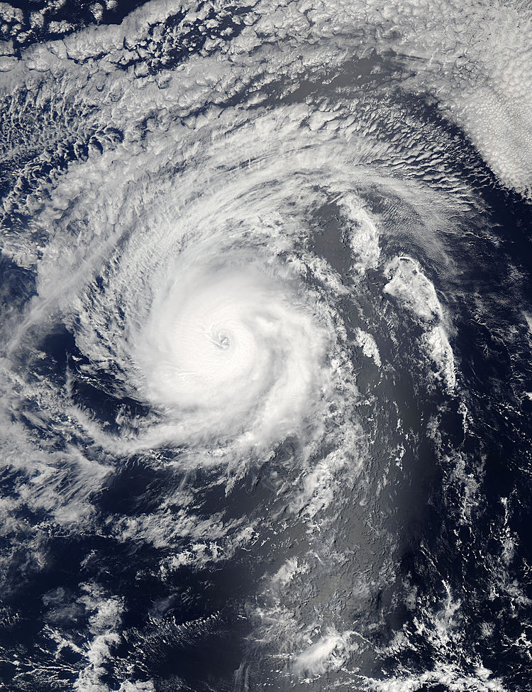
NASA's Aqua satellite captured this image of Hurricane Iselle (09E) in the eastern Pacific Ocean on August 3 at 6:05 p.m. EDT. Image Credit: NASA Goddard MODIS Rapid Response Team
There have been as many as five tropical systems at the same time. On Monday, August 4, there were three tropical systems stretching from west to east: Tropical Depression Genevieve in the Central Pacific, Hurricane Iselle and Tropical Storm Julio in the Eastern Pacific.
Tropical Depression Genevieve May Strengthen
On August 4, Tropical Depression Genevieve was located about 930 miles (1,495 km) southwest of Honolulu, Hawaii. Maximum sustained winds were still near 35 mph (55 kph). Genevieve was moving westward at about 16 mph (26 kph). NOAA's Central Pacific Hurricane Center forecasts gradual strengthening late on August 4 and 5, so Genevieve could once again reach tropical storm status.
To the east of Genevieve lies low pressure area known as System 93C. It is producing disorganized showers and thunderstorms. System 93C is located about 500 miles south of Hilo, Hawaii. This low pressure area is moving to the west at 15 mph and currently has a near zero percent chance of becoming a tropical depression over the next couple of days.
Hawaii on Guard for Hurricane Iselle
Behind System 93C to the east, lies Hurricane Iselle, the current powerhouse of the Eastern Pacific.
The Moderate Resolution Imaging Spectroradiometer or MODIS instrument that flies aboard NASA's Aqua satellite captured a clear visible image of Hurricane Iselle in the eastern Pacific Ocean on August 3 at 6:05 p.m. EDT. The image revealed Iselle's somewhat cloud-covered eye with bands of thunderstorms wrapping into the center from the eastern quadrant. The image was created by The MODIS Rapid Response Team at NASA's Goddard Space Flight Center in Greenbelt, Maryland.
On August 4 at 1500 UTC (11 a.m. EDT) Hurricane Iselle's maximum sustained winds had increased to near 140 mph (220 kph) Iselle is a category four hurricane on the Saffir-Simpson hurricane wind scale. The eye of Hurricane Iselle was located near latitude 16.2 north and longitude 136.5 west. Iselle was moving toward the west near 10 mph (17 kph). The National Hurricane Center noted that gradual weakening is forecast during the next couple of days. The estimated minimum central pressure is 947 millibars.
The current forecast track from the National Hurricane Center takes a weaker Iselle through the entire chain of Hawaiian Islands from August 7 through August 9.
Newborn Tropical Storm Julio Chasing Iselle
Tropical Storm Julio was born around 11 p.m. EDT on Sunday, August 3, about 795 miles (1,280 km) southwest of the southern tip of Baja California, Mexico.
On August 4 at 1500 UTC (11 a.m. EDT), Julio's maximum sustained winds were near 45 mph (75 kph). The center of Tropical Storm Julio was near latitude 13.5 north and longitude 119.4 west. Julio is moving toward the west near 13 mph (20 kph) and is expected to continue in a west to west-northwestward direction over the next couple of days. The estimated minimum central pressure is 1004 millibars.
Strong northeasterly vertical wind shear is pushing the strongest thunderstorms in Julio to the western side of the storm. The National Hurricane Center noted that the wind shear is expected to continue to August 5 or 6, which will limit any intensification. NHC expects Julio to become a hurricane later this week.
Satellites from NASA and NOAA continue to provide visible, infrared, microwave data to forecasters. Beginning in August, NASA's Hurricane Severe Storms Sentinel or HS3 mission takes to the Atlantic using two unmanned Global Hawk aircraft to study the storms. For more information about NASA's HS3 mission, visit: www.nasa.gov/HS3.
Text credit: Rob Gutro
NASA's Goddard Space Flight Center
Media Contact
More Information:
http://www.nasa.gov/content/goddard/iselle-eastern-pacific-ocean/All latest news from the category: Earth Sciences
Earth Sciences (also referred to as Geosciences), which deals with basic issues surrounding our planet, plays a vital role in the area of energy and raw materials supply.
Earth Sciences comprises subjects such as geology, geography, geological informatics, paleontology, mineralogy, petrography, crystallography, geophysics, geodesy, glaciology, cartography, photogrammetry, meteorology and seismology, early-warning systems, earthquake research and polar research.


Newest articles

Properties of new materials for microchips
… can now be measured well. Reseachers of Delft University of Technology demonstrated measuring performance properties of ultrathin silicon membranes. Making ever smaller and more powerful chips requires new ultrathin…

Floating solar’s potential
… to support sustainable development by addressing climate, water, and energy goals holistically. A new study published this week in Nature Energy raises the potential for floating solar photovoltaics (FPV)…

Skyrmions move at record speeds
… a step towards the computing of the future. An international research team led by scientists from the CNRS1 has discovered that the magnetic nanobubbles2 known as skyrmions can be…

