Satellite Video Captures the Eastern U.S. Winter Storm Track
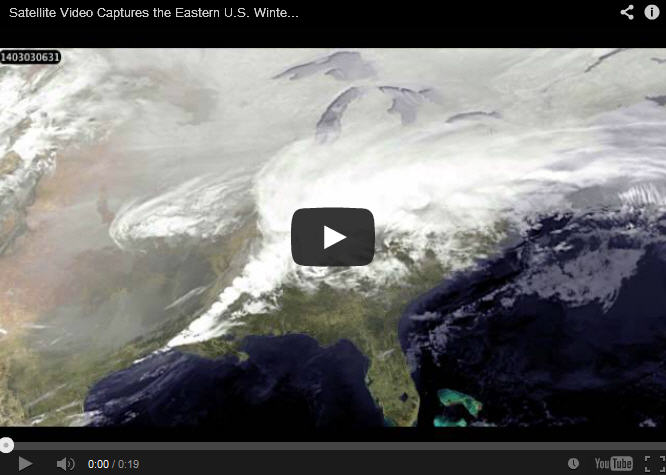
This animation of NOAA's GOES satellite data shows the progression of the major winter storm over the U.S. Mid-Atlantic and southern states on March 2 and 3. Image Credit: NASA/NOAA GOES Project, Dennis Chesters
On March 2 and 3, a major winter storm brought snow to the mid-Atlantic, freezing rain to the Carolinas and rain and some freezing rain to the Gulf Coast states.
Visible and infrared imagery over those two days captured by NOAA's GOES-East or GOES-13 satellite were compiled into a video made by NASA/NOAA's GOES Project at NASA's Goddard Space Flight Center in Greenbelt, Md.
“This storm confirms the ancient adage that 'March comes in like a lion,'” said Dennis Chesters of the NASA/NOAA GOES Project at Goddard. Hopefully it will follow the saying and the month will “go out like a lamb.”
To create the video and imagery, NASA/NOAA's GOES Project takes the cloud data from NOAA's GOES-East satellite and overlays it on a true-color image of land and ocean created by data from the Moderate Resolution Imaging Spectroradiometer, or MODIS, instrument that flies aboard NASA's Aqua and Terra satellites.
Together, those data created the entire picture of the storm and show its movement. After the storm system passes, the snow on the ground becomes visible.
GOES satellites provide the kind of continuous monitoring necessary for intensive data analysis. Geostationary describes an orbit in which a satellite is always in the same position with respect to the rotating Earth. This allows GOES to hover continuously over one position on Earth's surface, appearing stationary.
As a result, GOES provide a constant vigil for the atmospheric “triggers” for severe weather conditions such as tornadoes, flash floods, hail storms and hurricanes.
For updated information about the storm system, visit NOAA's NWS website: www.weather.gov
For more information about GOES satellites, visit: www.goes.noaa.gov/ or goes.gsfc.nasa.gov/
Rob Gutro
NASA's Goddard Space Flight Center, Greenbelt, Md.
Media Contact
All latest news from the category: Earth Sciences
Earth Sciences (also referred to as Geosciences), which deals with basic issues surrounding our planet, plays a vital role in the area of energy and raw materials supply.
Earth Sciences comprises subjects such as geology, geography, geological informatics, paleontology, mineralogy, petrography, crystallography, geophysics, geodesy, glaciology, cartography, photogrammetry, meteorology and seismology, early-warning systems, earthquake research and polar research.


Newest articles

Cause of rare congenital lung malformations
Gene mutations in the RAS-MAPK signaling pathway disrupt lung development in the womb. Most rare diseases are congenital – including CPAM (congenital pulmonary airway malformations). These are airway malformations of…

“Nanostitches” enable lighter and tougher composite materials
In research that may lead to next-generation airplanes and spacecraft, MIT engineers used carbon nanotubes to prevent cracking in multilayered composites. To save on fuel and reduce aircraft emissions, engineers…

Trash to treasure
Researchers turn metal waste into catalyst for hydrogen. Scientists have found a way to transform metal waste into a highly efficient catalyst to make hydrogen from water, a discovery that…

