Satellite Sees Miriam Weaken to a Tropical Storm
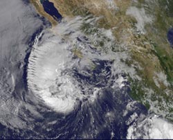
This visible image of Tropical Storm Miriam was captured by NOAA's GOES-15 satellite on Sept. 26, 2012 at 10:45 a.m. EDT off the coast of Baja California. The strongest thunderstorms were in a large band of thunderstorms north and northwest of the center.<br><br>Credit: NASA GOES Project <br>
Tropical Storm Miriam was seen in the Eastern Pacific Ocean by NOAA's GOES-15 satellite, and the visible image revealed that the strongest part of the storm was north and west of the center.
NOAA's GOES-15 satellite sits in a fixed position over the western U.S. that allows it to monitor the Eastern Pacific Ocean and it captured a visible image of Tropical Storm Miriam on Sept. 26, 2012 at 10:45 a.m. EDT off the coast of Baja California.
The image, created by NASA's GOES Project at NASA's Goddard Space Flight Center in Greenbelt, Md. showed that the strongest thunderstorms were north and northwest of the center in a large band, wrapping around the storm's center.
Wind shear is taking its toll on Miriam. The National Hurricane Center noted there is an increasing “separation between the low- to mid-level centers of the storm (think of the storm as having multiple layers) due to 20-25 knots of southwesterly shear associated with a shortwave trough (elongated area of low pressure) rotating around the northwestern side of the storm.
At 11 a.m. EDT on Sept. 26, Tropical Storm Miriam had maximum sustained winds near 65 mph (100 kph), dropping from 70 mph (100 kmh) just six hours before. It was located about 425 miles (680 km) west-southwest of the southern tip of Baja California Miriam was moving slowly at 6 mph (9 kmh) to the north-northwest and away from the coast. Miriam's minimum central pressure was near 992 millibars.
A Miriam continues to pull away from Baja California, rough ocean swells will keep affecting the south and west coasts today, Sept. 26, and tomorrow, Sept. 27. By Sept. 28, Friday, the ocean swells will gradually begin to subside.
Miriam is moving into a region where wind shear is forecast to increase and sea surface temperatures will fall. Those are two factors that will contribute to the weakening of the tropical storm over the next several days.
Text credit: Rob Gutro
NASA's Goddard Space Flight Center, Greenbelt, Md.
Media Contact
All latest news from the category: Earth Sciences
Earth Sciences (also referred to as Geosciences), which deals with basic issues surrounding our planet, plays a vital role in the area of energy and raw materials supply.
Earth Sciences comprises subjects such as geology, geography, geological informatics, paleontology, mineralogy, petrography, crystallography, geophysics, geodesy, glaciology, cartography, photogrammetry, meteorology and seismology, early-warning systems, earthquake research and polar research.


Newest articles

Bringing bio-inspired robots to life
Nebraska researcher Eric Markvicka gets NSF CAREER Award to pursue manufacture of novel materials for soft robotics and stretchable electronics. Engineers are increasingly eager to develop robots that mimic the…

Bella moths use poison to attract mates
Scientists are closer to finding out how. Pyrrolizidine alkaloids are as bitter and toxic as they are hard to pronounce. They’re produced by several different types of plants and are…

AI tool creates ‘synthetic’ images of cells
…for enhanced microscopy analysis. Observing individual cells through microscopes can reveal a range of important cell biological phenomena that frequently play a role in human diseases, but the process of…

